Saturday, December 29, 2007
手机上的GPS到底有没有用?
Jan@da 通过 Google 阅读器发送给您的内容:
其实第二篇的题目,想起为"手机上的GPS"到底有没有用?但是还是延续上一个标题比较好。
很多人可能知道,我们之前曾经做过一个关于手机GPS的活动,也是因为这个活动,诱发了我对手机GPS的想法。
其实之前,很多时候谈到独立的GPS对我而言没有用的原因,是一个笨重的屏幕放在车前,而除了导航对我来说没有什么其他用处。我的习惯是每次出发去一个地方的时候,先会用地图查询大概情况,然后去的时候靠路感寻找。那么这个时候,GPS对于我的作用则是,临时查看路况。
可是这样的情况偶尔发生,于是曾经和herock、SRC讨论GPS那块笨重的屏幕到底还能做其他什么用处?可视倒车雷达是一个不错的选择,而SRC则提出了用来卡拉OK。其实卡拉OK或者当作DVD屏幕也好,都是给附驾的玩意。主驾需要聚精会神的开车,唱K或者看DVD都是要命的东西。事实证明,很多高档汽车已经有了这样的系统。那么GPS那块笨重的屏幕还有什么用处?
是啊,现在能当作GPS使用的东西很多,包括PSP或者手机,尤其是手机,herock曾经很长时间用自己的手机做导航,在这个情况下,传统单纯的GPS似乎用处已然不大。
而手机导航这个概念似乎在年底的时候,格外的突出。不光我们看到在户外,有很多手机导航的广告牌。而在台湾,凯洛他们也参加过手机导航的互动营销活动。那么手机导航真得是王道吗?
我们当时活动采用的是高通的手机导航设备,具体的情况郑治的文章已经有说明。我的体验是还足够人性化,其中临时调整路线、摄像头警告和周边加油站查询这三项是我的最爱。与郑治坚决不采用GPS指定路线来测试GPS效果相反,我完全按照指示行事,基本上路线和我脑中之前想好的路线相同,有些小路让我意外。相信在上海这样的城市里面,或者是在北京望京地区,这个导航很有用处。但是在绝大多数时候,应该就是一个摄像头提醒和加油站查询的工具,我想我使用的频率很低。
那么怎样我会大量使用一个GPS呢?这是下一篇文章要谈到的事情。

可从此处完成的操作:
- 使用 Google 阅读器订阅吕欣欣-思想有什么未来
- 开始使用 Google 阅读器,轻松地与您喜爱的所有网站保持同步更新
Friday, December 28, 2007
Maps from another world
GMapType constants, which were added in the v2.95 Maps API:
* G_MOON_ELEVATION_MAP
* G_MOON_VISIBLE_MAP
* G_MARS_ELEVATION_MAP
* G_MARS_INFRARED_MAP
* G_MARS_VISIBLE_MAP
* G_SKY_VISIBLE_MAP
These work just like the familiar G_NORMAL_MAP and G_SATELLITE_MAP constants.
Geogle 通过 Google 阅读器发送给您的内容:
Google Moon and Google Mars are great examples of what can be done with the Google Maps API. But in the rush to get both products out the door, we never quite got around to going the extra step and providing support in the Maps API itself for the tiles that Google Moon and Google Mars use. Until now, that is!
Fresh out of the oven, Maps API v2.95 includes explicit support for Moon and Mars map types. Want to plan your next moon landing, maintain a database of alien colonies, or just keep track of things you've lost on Mars? All these things and more are now just as easy to do as creating any other Maps mashup. The sky's the limit!
Speaking of the sky... while we were at it, we didn't stop at Moon and Mars tiles. We added support for Google Earth's sky imagery, too. That's right, you can now use the Maps API to create web-based versions of the cosmos, pulling from our huge tileset of merged telescope images. Note that we haven't yet perfected inter-galactic geocoding or driving directions, so you'll have to stick to Earth maps when you want to search for pizza joints and coffee shops. At least for now.
Michael Kosowsky of HeyWhatsThat.com was kind enough to whip up some great example applications that make use of these new map types. You can use his Cosmic Visibility page to see and understand the phases of the Moon or Mars. You can even see where the planets are in the sky, and where the horizon is, custom-drawn for your specific time and location. We hope these are just the first of many science mashups created from this feature.
All of this is made possible by the following pre-defined GMapType constants, which were added in the v2.95 Maps API:
- G_MOON_ELEVATION_MAP
- G_MOON_VISIBLE_MAP
- G_MARS_ELEVATION_MAP
- G_MARS_INFRARED_MAP
- G_MARS_VISIBLE_MAP
- G_SKY_VISIBLE_MAP
Be aware that the sky data is referenced to the celestial coordinate system, which takes some getting used to for us Earth-dwellers. The vertical axis is known as declination, and the horizontal axis is right ascension (which increases to the left, unlike longitude which increases to the right). A good search engine can be used to help you find more info on this coordinate system. We also have some documentation of our own on this topic, for those interested in overlaying KML on the sky in Google Earth. Note that KML isn't yet fully supported on sky maps, due to the coordinate system reversal.
Now go create some other-worldly maps!
可从此处完成的操作:
- 使用 Google 阅读器订阅Official Google Maps API Blog
- 开始使用 Google 阅读器,轻松地与您喜爱的所有网站保持同步更新
Monday, December 24, 2007
产业白描:中国GPS发展这十年
发布时间: 2007-12-24 12:32 作者: 千龙科技 来源: 千龙科技
摘要
GPS业界流行这样一句话,"GPS的应用只受到人们想象力的限制"。目前GPS的民用领域已经包括了陆地运输、海洋运输、民用航空、通信、测绘、建筑、 采矿、农业、电力系统、医疗应用、科研、家电、娱乐等多个领域,而大家所熟知的汽车导航也只不过是其中的应用之一,2007年,我国GPS已经进入了一个 全面爆发期。据相关报告显示,日本的GPS系统车载使用率高达59%,欧美约为25%。而截至2005年底,中国配备GPS导航设备的汽车不足10万辆,与 2005年500万量的汽车销售量相比,中国汽车的GPS系统车载率不到2%。用户迫切的需求造成了巨大的市场空洞,时刻寻找着利润增长点的各大IT厂商 也蜂拥而至,或彻底转型或拓展业务,开始抢占这个巨大的蛋糕。不但如此,GPS产业的迅猛发展还同时影响了 其他并行产业链的发展,并使其交叠融汇,这也使得大量带有GPS功能的PDA、MP4、相机、手机等手持终端设备成为现今市场上的一大主流。
据近期ABI公司研究报告显示,2008年GPS功能的移动电话将产生500亿美元的收入,到2012年这一数字将达到1000亿美 元。市场对这类手机的需求量也将由2008年的2400万台增长到2012年的5500万台以上。可见不论是只有高端车型才能涉足的前装市场,还是面向大 众消费的PND、PDA以及手机产品都取得了良好的发展,同样随着中国市场近两年汽车保有量激增以及2008年奥运临近,导航产业的发展更将呈现明显的 "井喷"之势。
截止至2007年,市场上出现的GPS品牌多达千余,除了诺基亚、摩托罗拉这样的手机巨头,和专注与此产业的神行者、奥可视等著名品牌外,其他小作坊出品更是多如牛毛。面对GPS这样的新兴产品,消费者在选购时更需要小心谨慎,选择那些正规的、有 技术含量的、有历史积淀的品牌的产品。
据业内专家阐述,GPS分为软硬件两个部分,硬件部分技术较易实现,这也是为什么有这么多GPS品牌的原因所在,而相比硬件,软件及其内置的导航电子地图 则有着较高的门槛,至今为止,通过国家甲级测绘资质的公司只有11家而已。另外对于导航应用来说,信息点的多寡、路网的覆盖程度、导航引擎的算法都是至关重要的,所以要想选择一款质量上乘的GPS,硬件的品质不可或缺,软件更是需要特别注意。
纵观这几年来国内GPS行业的发展,移动导航系统的发展异常迅猛。在这个过程中,目前移动导航领域的第一品牌凯立德的成长轨迹尤其值得关注,因为凯立德在成立之初并不是从事GPS行业,而是以国家 地理信息系统( GIS)的研发及国土测量起家,但是作为国内成立最早的移动导航系统厂商,凯立德的发展也可以说是国内GPS产业发展史的缩影。
与互联网普及这种典型的数字化应用相比,国土资源信息化对于普通老百姓来说显得较为陌生,似乎离我们的日常生活有 很大的距离。其实,国土资源信息化既是我国国民经济与社会信息化的重要组成部分,也是实现国土资源管理现代化和促进国土资源事业发展的关键。其对于促进国 家社会经济可持续发展,优化资源利用结构,保障国家资源安全,具有极为重要的意义,而我国的GPS产业也是从GIS慢慢衍生而来的。
97年,国内第一家从事专业移动导航系统研发的凯立德公司正式成立,并受到政府委托建设中国自己的国家地理信息系统,并对商业用地进行实地测绘,至此国内GPS行业的发展的大幕也被缓缓拉开,同时凯立德也被誉为中国国土资源信息系统构架师,其 开发的系统被国家沿用至今。随着GIS产业的不断成熟,GPS的相关应用也随着国外GPS产业的逐渐升温而被重视,凯立德于99年首先进入了GPS领域。同年,另外一家通过国家甲级测绘资质的 灵图也宣布成立,并开始了集软件研发、地图生产及相关服务在内的移动导航系统开发。2000年瑞图万方加入国内移动导航系统开发的队列,GPS软件研发队伍不断壮大。
如今相对于国际上对GPS的多方应用,国内确实有所不如。但是在GPS产业发展的初期,却同样处于一种无序的状态。要知道,自1996 年美国政府签署GPS总统法案,并确定GPS系统无偿开放给民间也仅仅几年时间,当时,虽然各大机构都很看好GPS未来的发展,但在国际上并无标准出台, 这将对未来GPS的发展将造成极大的阻碍。所以在二十一世纪初,也就是2001年国际上开始制定国际通行GPS标准《ISO/TC204-WG3.4导航 数据标准》,而凯立德则成为国内唯一参加国际GPS标准制定的企业被载入国内GPS的发展史。
02到03年是国内移动导航系统厂商取经的两年。02年四维图新正式成立,并且在当年应日本丰田公司的委托推出了一款真正的商业化 导航电子地图产品。这款产品主要在丰田汽车公司的威驰车上,并得到了用户的广泛好评。03年,凯立德受国际汽车制造公司委托对车载前装GPS系统进行研 发。经过严格的检测和审核,凯立德研发的导航系统完全符合车厂标准,最终获得多家国际车厂的前装认证。通过这种"委托研发"的形式,国内的移动导航系统厂 商开始有了实际的产品,虽然还没有完全摆脱国外汽车厂商的"操控",但是对于国内的GPS产业发展来说,却是宝贵的经验。
04年到05年是令人振奋的,因为在这两年间,凯立德凭借其与国际汽车公司丰富合作经验,通过自主研发,在国内首次完成了将专业级 车载导航仪移植到便携终端的工作,实现了包括数码相机、PMP及手机在内的手持便携设备应用,这为GPS展现了一个更为宽广的舞台,摆脱了汽车的束缚,依 靠手机等便携设备的移动性和便携性,一些物流监管、行车导航、设施搜索、定位监控,甚至紧急援助、野外求生等一系列应用得到了更好的发挥。05年,国内首 款支持手机的导航系统由凯立德正式研制成功,这是国内GPS行业发展的一大标志性事件。
06年被业界称为国内GPS产业发展的元年,在这一年国内的GPS产业实现了高速的增长。在这一年发生了两件标志性事件,首先是大 量廉价PND方案发布,各大硬件厂商的生产成本得到了更好的控制,PND的价格由原来的天价慢慢走下神坛,给了普通消费者选择的机会,增加了GPS的普及 速度;另外一件就是凯立德正式发布了国内第一张全覆盖地图,由于在06年以前GPS的硬件制作技术已经相对成熟,但却没有一块完整的导航电子地图能够实现 全国范围内的导航,可以说当时的GPS导航仪不是不可用,而是不好用,凯立德全覆盖地图的发布从根本上解决了GPS行业发展的一大瓶颈,解决了GPS普及 上的一个难题。
07年GPS井喷式发展,移动导航在非智能手机上的应用使产业的发展速度成几何级增长。据专家统计,PND今年的销量大概在百万台 左右,而非智能手机的销量却在一亿台以上,非智能手机上的导航应用使得国内GPS产业的应用平台得到了进一步扩展,并真正让导航应用步入了千家万户。从 97年到2007年,国内的GPS产业仅仅经历了十年的历程,但是整个GPS产业在国内的发展已经势不可挡。
据近期由信息产业部下属的赛迪顾问发布的07年第三季度中国后装导航地图软件市场分析报告显示,凯立德、灵图、城际通三大移动导航系统 厂商分居三甲,其他如瑞图万方、四维图新、高德等厂商也占据了较大的份额,其中凯立德以40.1%的市场占有率再次卫冕成功,甚有成为国内移动导航系统第 一品牌的趋势。
伴随着国内GPS产业发展的十年,凯立德也迎来了他的十年庆典,他伴随着国内的GPS产业经历了一个从无到有,从依靠国外厂商到能 够自主研发的历程,从凯立德走出的每一步我们看到了技术的进步,看到了产业的发展,更将看到GPS多方应用的未来。十年是漫长的,但是对于一个产业的发展 来说却仅仅是沧海一粟,面对着消费者需求的变化及未来的应用确实,国内的GPS产业将走向何方?让我们拭目以待。
--
<table style="font-size: 24px; color: rgb(85, 85, 85);"><tbody><tr><td><img src=" http://geography.wincoll.ac.uk/graphics/geogle.jpg"><font color="blue"><strong>@Gmail.com</strong></font><br><img src=" http://geogle.googlepages.com/Geogle.GIF"><br></td></tr></tbody></table>
Sunday, December 23, 2007
The best of the blog
参考消息 通过 Google 阅读器发送给您的内容:
Since the start of Google Lat Long back in May, we've had fun keeping you updated on all the exciting new developments in the geo world -- from product launches and innovative user-created content to the evolution of the geoweb in general. As the year comes to a close, we thought we'd take a moment to look back at some of the greatest moments in news and notes by the Google Earth and Maps teams.
Street View
Since the launch of Street View in May, our post introducing the service remained one the top five most read posts consistently throughout the year. And "street view" was one the most common search keywords. So just as we did earlier this month in announcing 8 new Street View cities, we'll be sure to keep you posted on new city rollouts.
Google Earth Outreach
We heralded the arrival of this exciting new program for non-profits with a post that pointed to video footage of our kick-off event at our New York office. The video featuring an appearance by Jane Goodall was viewed over 22,000 times.
My Maps and Disaster Relief
When the My Maps tab was added to Google Maps earlier this year, we were eagerly anticipating all the cool and creative custom maps folks would be coming up with. However, we were positively floored to find the incredible maps made to aid areas in need. From flood maps created by "citizen journalists" and by BBC Berkshire to the San Diego fire maps and the Google Earth layer of Southern California imagery, the astonishing number of views pointed to new ways to help.
Sky in Google Earth
Another top post of the year, our note introducing the addition of a new Sky view in Google Earth, caught the attention of many Lat Long readers. Google Earth aficionados are able to zoom in on distant galaxies and explore constellations and supernova explosions from the comfort of their computer screens. A list of great tips on how to use Sky in Google Earth for educational purposes followed, and you can expect more updates in the new year.
YouTube videos in Google Earth
Ever watched a funny, intriguing, or outrageous YouTube video and wondered where it came from? Well, we have too. That's why we were so excited to announce the addition of a new YouTube layer in Google Earth. Videos geotagged in YouTube are included in this browseable layer, making it easy to view clips associated with a location of your choice.
Maps Mania!
2007 saw the addition of a number of great new features in Google Maps, perhaps too numerous to count. Early on in the year, the creation of the My Maps tab and the addition of countless Mapplets enabled just about anyone to create their own mashups. Throughout the year, searching for accurate and helpful directions got a whole lot easier with the launch of draggable directions and the ability to read and write user reviews of businesses, as well as edit address markers. Finally, mapmakers enjoyed the addition of cool new Maps functionalities towards the end of the year, including the ability to both collaborate on customized maps and embed them wherever you see fit, as you might a YouTube video.
As you can see, this year's been a busy one. We're all looking forward to a few days of rest and holiday cheer. And with that, we must bid adieu -- happy holidays and a wonderful new year from all of us at Google Lat Long! Stay tuned for more geo news and notes in 2008, and don't forget to track Santa!
可从此处完成的操作:
- 使用 Google 阅读器订阅Google LatLong
- 开始使用 Google 阅读器,轻松地与您喜爱的所有网站保持同步更新
GPS到底有没有用(一)
Jan@da 通过 Google 阅读器发送给您的内容:
从去年开始,GPS的广告就越来越多了,无论是单纯的GPS设备,还是有GPS功能的手机,仿佛一夜之间窜了出来,北京的大街小巷,很多的广告牌都换成了和GPS相关的。
也许很多人不知道,在组建Feedsky之前,邢勃同学做过一段日子的GPS生意。我们曾经拿过一个来试用。
那真的是一个很笨很笨的东西,银幕大,但是显示并不好。语音导航的时候,总是给你一些模棱两可的选择,让你一会朝右并线,一会朝左并线,而且地图的更新似乎有点慢。总之如果你真得完全依赖它的话,那么绝对"抓瞎"。
后来Webleon的一席话似乎也证实了这个观点,在那种固执的如同牛一般的德国人里面,完全依赖GPS的人大有人在。甚至出现过完全依赖GPS,而造成跌入前面一个大坑的事故发生。所以那个时候,我一直都认为其实GPS没有什么用处。
去年买车的时候,4S店送大礼,包含GPS、可视倒车雷达、DVD等N合一的一个大礼包。我觉得除了倒车雷达,其他都没有什么用处,于是毅然拒绝,然后把礼包的钱折成车价,直接折扣掉了。而后来我的习惯则是利用网络地图大概知道一个位置,然后凭着感觉寻找。反正大不了就重来一次好了。
在后面的经验里,这种方式不仅可行,而且还加强了我对道路的记忆能力。相反一直依赖GPS的夏裤子同学,则经常在GPS的指引下四处抓瞎。甚至发生过那次著名的全聚德羞辱事件。后来夏裤子放弃了GPS,反而认路清晰,有了显著的提高。
所以在很长很长的时间里面,我都对GPS不是很感兴趣。觉得有网络的地图也就可以了。当然,如果去外地自驾游的话,那么GPS也许还有用处。这里面有个趣事,那年我和邢勃一起开车回北京,中间在太原住了一宿。到太原的时候已经是晚上,人生地不熟的。于是我们打开广播想看看有没有当地的交通台,结果听到的第一句话就是"你只有前面这一条路可走了。"
后来我们也曾经自驾去过天津,我也曾经去过很多北京临近的城市。但是往往地图能帮到我很大的忙,而我始终没有养成使用GPS的习惯。但是并不是说GPS没有用处,郑治之前曾经参与过一个GPS的现场推广,是我们的客户,在那个活动中,我还是发现了一些GPS的优势。而这些,我用下回分解吧。

可从此处完成的操作:
- 使用 Google 阅读器订阅吕欣欣-思想有什么未来
- 开始使用 Google 阅读器,轻松地与您喜爱的所有网站保持同步更新
Friday, December 21, 2007
My Maps are Our Maps
Sent to you by 参考消息 via Google Reader:
The tools used for navigation and exploration are fraught with metaphorical possibility. A compass or telescope can be a powerful symbol for search, discovery, and the fearless embrace of the unknown. A map can tell you where you are, give you an idea of what lies ahead, and even better, give scale and breadth to your location. Maps connect us with the world in a way that is tangible, visual and now, even interactive.
And for any of the myriad places you can point to on a map, there are traditions, stories, pictures and memories -- each is as unique and fascinating as its teller. For this year's holiday season we've created a My Map for you to customize.
View Larger Map
Mark your place in the world with photos, video and stories that illuminate something about how you celebrate. Your stories can make for a considerably bigger map than any featuring geopolitical boundaries and highway markers; they can mark a human space of Chanukah candles, Christmas trees, family feasts and reunions great and small. We look forward to seeing how you make your mark.
Things you can do from here:
- Subscribe to Official Google Blog using Google Reader
- Get started using Google Reader to easily keep up with all your favorite sites
Thursday, December 20, 2007
The Googleplex
参考消息 通过 Google 阅读器发送给您的内容:
As part of the December 07 image update Google have updated their own headquarters in Mountain View, California.

Compared to the older imagery1 the most obvious difference is that the Googeplex has been absolutely covered in solar panels.
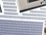
Installed in October 2006, the panels are the world's largest solar panel installation on a corporate campus in the United States! Er, hang on…
Still, Google should be commended for the project which generates 30% of their peak electricity requirements. Read more on the project's homepage, which also promises some live stats2.
Locations: California / Categories: Buildings
You're reading an entry from Google Sightseeing, which is copyright © 2007 Alex Turnbull & James Turnbull and must not be reproduced without permission.
可从此处完成的操作:
- 使用 Google 阅读器订阅Google Sightseeing
- 开始使用 Google 阅读器,轻松地与您喜爱的所有网站保持同步更新
Wednesday, December 19, 2007
Where in the world is... (Answers)
Sent to you by janada via Google Reader:
Great detective work, everyone. As always I am very impressed at the speed with which the blogosphere finds these updates. Here's a list of answers to the clues, as well as a more complete listing of updates.
1) A young boy living in this town designed the Alaska state flag 32 years prior to Alaska
gaining statehood.
-- 13 year old Benny Benson designed the current Alaska state flag while living in Seward, AK.
2) The incredible ruins of an old medieval castle, believed damaged during the Swedish
invasion of 1655, are now visible in Google Earth.
-- Ogrodzieniec, Poland

3) On July 3, 1810, this city declared independence from Spain.
-- Santiago de Cali declared independence from Spain 17 days before the national revolt in Bogata. It wasn't until 1819 that Colombia won its freedom.
4) This city's metropolitan area is the most populous in the world, with over 35 million people.
-- Despite a national declining population, the greater Tokyo area has held this title since the 70's.
5) This city, known as the City of Peace for hosting many peace conferences, is a popular
tourist destination.
-- Sharm el-Sheikh, Egypt. Check out the amazing Panoramio photos people have taken of this resort hot spot.
6) The oldest Polish cathedral, burial site of many famous Polish leaders, is now high res.
-- The Archcathedral Basilica of St. Peter and St. Paul in Poznan, was first constructed in the second half of the 10th century.
7) This Jersey city is now high res.
-- I said Jersey, not New Jersey. ;) Saint Helier, the capitol of Jersey (a British Crown Dependency located off coast of Normandy) is now high res.
8) Lawrence of Arabia and Cleopatra were both shot at this famous studio.
-- Atlas Studios in Ouarzazate, Morocco.

9) This city is also Ukraine's largest port.
-- Odesa, Ukraine
10) Though completely destroyed in an 1868 fire, this gold rush town was completely
restored by the government of British Columbia to act as a tourist attraction.
-- Barkerville, British Columbia

11) This was the final port of call for the Titanic before it's ill-fated transatlantic journey.
-- Cobh, Ireland, where the Titanic picked up most of it's third-class passengers.
12) Bach, 38 at the time, was appointed the cantor for St Thomas' Church in this city
-- Leipzig, Germany
13) This deep-water port was constructed in the middle of a bay and is connected to the
mainland by the third longest bridge in the world.
-- You can view the incredible infrastructure development at the Yangshan deep-water port outside of Shanghai.

14) The element Hafnium is named after this city's Latin name.
-- Hafnium was named after Copenhagen's Latin name: Hafnia.
15) The picturesque port in this city has been painted many times over, and helped inspire
the Impressionist movement.
-- The port of Honfleur, France was painted by the likes of Gustave Gourbet, Claude Monet, and Johan Jongkind.
16) Famous as the site where Portuguese explorer Pedro Álvares Cabral landed in Brazil, this
city is now a tourist destination.
-- Pedro Álvares Cabral, thinking he had landed on an Island, originally named Porto Seguro The Island of the True Cross.
17) The imagery above the headquarters of my favorite search engine has been upgraded!
-- The Googleplex in Mountain View, California!

Here's a more complete list of imagery updates in this data push:
New high resolution:
Americas:
- Canada: Significant amount of British Columbia
- USA: Jefferson City (MO), Central Virginia, Tioga County (NY), Cayuga County (NY),
Jefferson County (NY), Broome County (NY),
- Brazil: Uberlandia
- Colombia: Cali, Pasto
- Mexico: Veracruz
Europe, Middle East and Africa:
- France: Le Havre, Dunkerque
- Russia: Yaroslavl, Ivanovo, Vladikavkaz, Volzhskiy, Barnaul
- Ukraine: Rivne, Odesa
- Morocco: Agadir
- Nigeria: Abuja
Asia & Oceania:
- New Zealand: Manawatu Wanganui Province, Thames-Coromandel Province
- China: Guiyang, Zhaoqing, Zhongshan, Neijang, Anshun, Zhuzhou, Changde,
Jiaoijang, Sashi, Qinhuangdao, Mudanjiang
- Indonesia: Sukabumi, Surakarta
2.5m imagery for the eastern half of Egypt.
Updated Imagery:
Americas:
- Canada: Calgary
- USA: Bend (OR), Reno (NV), Googleplex (CA), San Miguel (CA), Paso
Robles (CA), Buellton (CA), Thousand Oaks (CA), Los Angeles (CA), Orange
County (CA), Denver (CO), Saint Louis (MO), Knoxville (TN), Chattanooga (GA),
Dayton (CA), Atlanta (GA), Desoto County (FL), Onondaga County (NY), Cayuga
County (NY), McAllen (TX), Sanger (CA), Bellevue (WA)
Europe, Middle East and Africa:
- France: Nantes, Lyon
- Germany: Sindelfingen, Ausburg, Leipzig, Aachen
- Denmark: Entire country
- Niger: Niamey
- Zimbabwe: Harare
- South Africa: Johannesburg
- Iran: Tehran
Asia:
- Japan: Tokyo, Osaka, Nagano
- Thailand: Bangkok
- Vietnam: Hanoi
Antarctica: new 15m imagery
Updated Terrain:
Massachusetts
Things you can do from here:
- Subscribe to Google LatLong using Google Reader
- Get started using Google Reader to easily keep up with all your favorite sites
Tuesday, December 18, 2007
Where in the world is ...
Sent to you by 参考消息 via Google Reader:
Hello, geo fans!
Today I'm very happy to announce that we've published a large amount of new imagery all over the world. I'm particularly happy to say that every continent on Earth has received a certain amount of new imagery in this update. I hope you enjoy discovering the amazing new sights to be seen -- below are some clues that might point you toward some interesting areas.
1) A young boy living in this town designed the Alaska state flag 32 years prior to Alaska gaining statehood.
2) The incredible ruins of an old medieval castle, believed damaged during the Swedish invasion of 1655, are now visible in Google Earth.

3) On July 3, 1810, this city declared independence from Spain.
4) This city's metropolitan area is the most populous in the world, with over 35 million people.
5) Known as the City of Peace for hosting many peace conferences, this city is a popular tourist destination.
6) The oldest Polish cathedral, this burial site of many famous Polish leaders is now high res.
7) This Jersey city is now high res.
8) Lawrence of Arabia and Cleopatra were both filmed at this famous studio.

9) This city is also Ukraine's largest port.
10) Though completely destroyed in an 1868 fire, this gold rush town was completely restored by the government of British Columbia to act as a tourist attraction.

11) This was the final port of call for the Titanic before it's ill-fated transatlantic journey.
12) Bach, 38 at the time, was appointed the cantor for St Thomas' Church in this city.
13) This deep-water port was constructed far offshore and is connected to the mainland by the third longest bridge in the world.

14) The element Hafnium is named after this city's Latin name.
15) The picturesque port in this city has been painted many times over, and helped inspire the Impressionist movement.
16) Famous as the site where Portuguese explorer Pedro Álvares Cabral landed in Brazil, this city is now a tourist destination.
17) The imagery above the headquarters of my favorite search engine has been upgraded!

Have fun exploring, everyone!
Things you can do from here:
- Subscribe to Google LatLong using Google Reader
- Get started using Google Reader to easily keep up with all your favorite sites
Antarctica: A Virtual Expedition
Sent to you by 参考消息 via Google Reader:
Pssst... wanna see a nunatak? Feeling the urge to check out some seracs? If so, then it's time to fire up Google Earth and check out Antarctica in greater detail than ever before through our new high resolution satellite view of the coldest continent. The U.S. Geological Survey (USGS), the British Antarctic Survey (BAS), and the National Aeronautics and Space Administration (NASA), with funding from the National Science Foundation (NSF), created Landsat Image Mosaic of Antarctica (LIMA) from more than 1,000 Landsat ETM+ scenes. LIMA covers all of Antarctica, with the exception of the South Pole at 90 degrees south to 82.5 degrees south latitude, where there's no coverage because of its near-polar orbit.
We're really happy about this new imagery, but we'd love to see more user-contributed content. Sure, it's a tough place to get to, but we know that Google Earth aficionados tend to be more adventurous than most. So if you've been to Antarctica on a cruise, an expedition, or just because, be sure to geotag your YouTube videos, upload your photos to Panoramio, and model some research stations in SketchUp so the rest of us can explore the snowy expanse from the warmth of our glowing computer screens. And please pass the word along to the explorers in your lives.

Things you can do from here:
- Subscribe to Google LatLong using Google Reader
- Get started using Google Reader to easily keep up with all your favorite sites
To grandmother's house we go
Sent to you by 参考消息 via Google Reader:
This Friday, I'm packing up the car and taking my pooch, Oscar, along for the ride over the river and through the woods to Portland, Oregon. And I'm picking up my cousin Lily on the way in Colusa, California. The entire trip should take a good 10 hours or so from my home in San Francisco. Luckily, I've got all sorts of mapping tools at my disposal that should help make my trip relatively hassle-free.
The first thing I did to prepare for the trek was create a map using tools in the My Maps tab. I did a quick search for directions from San Francisco to Colusa, then clicked the "Add destination" link at the bottom of the directions to find a route to Portland. Next, I clicked over to the My Maps tab and created a new map, entitled "To grandmother's house we go!" From there, I selected the GasBuddy gas station prices mapplet that I found in the Google Maps directory to find the cheapest pumps on my route. I scanned the markers around the halfway point of my trip where I knew I'd be needing to fill up, and found a great deal at a Medford, Oregon station. I made sure to save the marker to my personal map.
Now, I know what you're thinking: with Oscar in the car, we're going to need to make one more bathroom stop between the gas station and Portland. I decided to consult the directory again to see if there were any parks along the way and came across a fantastic mapplet pinpointing parks in Eugene, Oregon.
And what's a road trip without stopping for snacks? I did a search for fast food near Eugene and discovered a Wendy's mere miles from our park of choice.
If all goes according to plan, we should be arriving in Portland just in time for dessert. I decided to do a quick scan for bakeries near granny's house to pick up something for the family. I came across a place called Papa Haydn that had received high marks from Maps users. I might even have GOOG-411 connect me to the restaurant so I can have the pie waiting for me when I get there.
You can check out my completed map here. Now, the only thing standing between me and grandma now is that nasty holiday traffic, but you can bet I'll be enabling the traffic overlay in Google Maps before I hit the road.
Things you can do from here:
- Subscribe to Google LatLong using Google Reader
- Get started using Google Reader to easily keep up with all your favorite sites
Thursday, December 13, 2007
Google Maps Integrates Video, Book & Photo Results
Sent to you by 参考消息 via Google Reader:
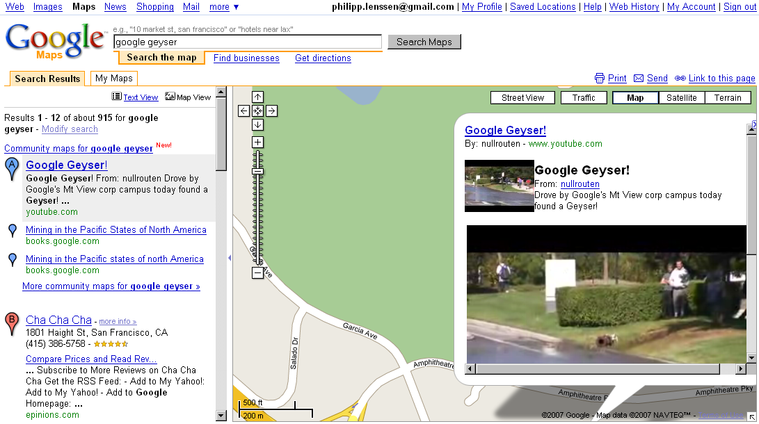
A Google Maps search may now return location markers showing videos from YouTube, books from Google Book search, or geo-tagged photos from Panoramio*. Try the query google geyser, for instance, and you will find the blue placemark's info window will embed a YouTube video for direct playback... possibly retrieved because the description, tags or title of the video contained the keywords in question as well as location information (the description reads "Drove by Google's Mt View corp campus today found a Geyser," and tags include mountain view).
The integration of the YouTube results looks very half-baked, as the screenshot shows (there's not enough padding between thumbnail and description, the thumbnail is redundant in the first place because the embedded video contains a preview still already, the embedded video is too large for the info window, etc.).
To see book results, Google at the official Google Lat Long blog suggests you search for christmas books in jerusalem. Photo results can be pulled up by searching for e.g. big ben in london.
*Panoramio is a Google property as well; let's see if Google will index and display other photo and video properties in their maps results too, like data from Flickr, for instance. The quality of Google's services will suffer if they become too self-referential.
[By Philipp Lenssen | Original post | Comments]
[Advertisement] Need a dream team? Look no further than ACS! [Advertise here]

Things you can do from here:
- Subscribe to Google Blogoscoped using Google Reader
- Get started using Google Reader to easily keep up with all your favorite sites
Wednesday, December 12, 2007
微软中国也出地图了

--
从头再来!灌水民工
参考消息@无所不坛
http://groups.google.com/group/Go2group
更多精彩, 请 google.com/group/Googroup
Tuesday, December 11, 2007
Google Earth From Above, New Layer
Sent to you by 参考消息 via Google Reader:
French photographer Yann Arthus-Bertrand's beautiful images of the planet have become a coffee table favorite across the world. Today we are excited to present a new Google Earth layer of nearly 500 of his images, many taken from hot air balloons and all taken from above the earth. Each image is paired with thought-provoking statistics about the current environmental situation they depict. The facts and figures were put together by GoodPlanet.org, Yann's non-profit organization established to promote environmental awareness and sustainable development.

In June this year, we launched Google Earth Outreach, a program to empower non-profit groups with resources and tools to use Google Earth to promote their cause. Today's new "Earth From Above" layer (located in the Global Awareness folder in Google Earth) is an excellent example of what such groups can accomplish.
Not only can you enjoy these stunning new photographs on Google Earth -- we're also launching an iGoogle gadget you can add to your personalized Google homepage to see a different image each day. You can find the iGoogle gadget and a YouTube interview with Yann here. We hope you enjoy them!
Things you can do from here:
- Subscribe to Official Google Blog using Google Reader
- Get started using Google Reader to easily keep up with all your favorite sites