Saturday, December 27, 2008
山石网络的64位并行安全操作系统StoneOS
Sent to you by 参考消息 via Google Reader:
下面的文字是笔者从山石网络网站上找到的相关资料。希望有兴趣的读者可以发表评论。我大概看了一下其体系结构框图,感觉存在一些问题。我个人的意见和评论如下–陈怀临
1. 整个安全软件系统环境叫做StoneOS更概念正确一些,而非是一个middleware层叫做StoneOS。 目前标注的StoneOS可以(应该)改成StoneKernel才概念完整。另外,其Fabric应该取名为StoneFabric。这样就很完整。整个软件系统叫做StoneOS。优化或裁剪的Kernel叫StoneKernel。ASIC叫StoneASIC。
2.从图示,我们可以看见FW,VPN(对网络安全有兴趣的读者应该知道,这里其实是指IPSEC的Control,如IKE。IPSEC应该是在StoneASIC里面做了大部分了)。P2P比较有意思。是个亮点。ALG在StoneOS里,这是情理之中。QoS这个比较有意思。QoS确实是个大难点。希望HillStone有更大的ASIC话的空间。
3.从计算机世界实验室的测试来看,StoneOS和StoneASIC对AV方面的功夫下的很大。如接近2Gbps的AV性能。 确实不错。从其体系结构来看,应该是全部靠CPU来做的。这方面其实还有空间,如通过Cavium或StoneFabric(希望山石网络启用我创造的词汇)的PCI-E Interface做或买一个AV的FPGA加速器等。
| 专用实时64位并行安全操作系统StoneOS | ||||
| ||||
| 众 所周知,操作系统是整个安全设备的核心和基础,安全产品的操作系统必须具有很强的抗攻击能力,而基于软件的安全系统采用的是通用的操作系统,通用操作系统 会暴露大量的操作系统漏洞,安全系统再强大,操作系统的漏洞会直接导致这个系统的崩溃。目前,专用定制的操作系统被广泛采用。Hillstone系列产品 均采用定制的专用操作系统StoneOS。StoneOS具有64位实时并行处理能力,其核心针对Hillstone硬件产品进行了全面优化,使得系统具 有更高的处理效率和稳定性。模块化的系统结构易于集成更多的安全功能,系统具有极强的伸缩性和可扩展性。任何独立的安全模块出现问题都不会影响整个系统的运行。 | ||||
|
| ||||
|
|
Things you can do from here:
- Subscribe to 弯曲评论 using Google Reader
- Get started using Google Reader to easily keep up with all your favorite sites
Thursday, December 25, 2008
谷歌推中国历史地图 首张图为赤壁之战
谷歌中国在接受采访时表示,该功能是上周推出的,目前仅提供历史事件"赤壁之战"的地图,未来将会提供更多张历史地图。(完)
参考消息 通过 Google 阅读器发送给您的内容:
12月22日消息 近日,谷歌中国推出了一项名为"历史地图"的新功能,首张历史地图为"赤壁之战",包含有赤壁之战期间12个历史事件的地理信息,以及相关的人物、事件等文字信息。
谷歌中国在接受采访时表示,该功能是上周推出的,目前仅提供历史事件"赤壁之战"的地图,未来将会提供更多张历史地图。(完)

可从此处完成的操作:
- 使用 Google 阅读器订阅Google(谷歌)实验室
- 开始使用 Google 阅读器,轻松地与您喜爱的所有网站保持同步更新
Tuesday, December 23, 2008
赤壁之战地图,带你回到一千八百年前
参考消息 通过 Google 阅读器发送给您的内容:
在谷歌的食堂吃饭、侃大山,有时候就会成为谷歌产品的起源。某日中午,一伙人打着纪念赤壁之战一千八百周年的名目在餐桌上大聊三国,又正逢头顶电视中正有新闻讲到电影《赤壁》的下集上映在即,此时此刻,就迸发了做一个赤壁之战相关项目的念头。
于是下午一封群体信发给了所有的工程师,征集对三国以及对中国历史和地理感兴趣并愿意贡献 20% 时间的人手,部队就这么拉了起来。俗话说:三个臭皮匠顶个诸葛亮,我们的人虽然不多,但坐下来开个会至少也能顶三个诸葛亮了。第一次会议的议程是确定产品目标和技术方向。因为只是一个 20% 的项目,于是我们选择了使用 Mapplet 进行开发。Mapplet 是在 Google 地图中运行的迷你程序,换句话说,就是地图上的 Gadget,任何第三方开发者都可以开发,简单快捷,完全符合我们短平快的需求。接下来进行分工,大家各自认领自己擅长的部分。地图组负责渲染一幅东汉末年的地图,资料组定下数据结构,并负责查阅史书,整理史料数据,而开发组则负责用 Mapplet 技术开发,三个组各自获得一个诸葛亮。
之后的事情就是每天在工作的闲暇时候找几篇资料或是写几行代码,并通过邮件进行一些讨论与交流。没有老板,也没有时间表,所有的东西都是大家自己琢磨和讨论出来的,每周一次的组会仅仅开到第三次,产品的原型就完成了,随后就是修改 Bug,美化页面,填充史料,这时候已经没有了小组的分工,谁看到了程序 Bug,看到了数据问题,就直接去改,于是一周后的会议上,完整的赤壁之战地图(ditu.google.cn/chibi)已经等待发布了。
赤壁之战地图上包括了东汉末年全国各州郡治所的城市,部分知名县城、战场。如果对比古今地图,还能看到海岸线、湖泊以及黄河河道的古今变迁。可以在左边下拉框选择半透明层叠模式查看地图进行对比(IE6 无法支持这项功能)。

要查看相关的事件有两种方法:一是在"历史事件"选项卡里,按照历史事件发生的顺序查看,从三顾茅庐到周瑜逝世,我们赤壁之战前后若干年间分成了十二个大事件,大家可以从这里追述当年的一连串大事小事和各个部队的进军路线;二是在"主要人物"选项卡里,点击不同的人物,就可以看到每一个有关的历史人物在这段历史中所走过的轨迹。地图上的箭头和小旗子都可以点击查看当前这个事件的文字记载。用到的所有的数据与资料,都以《资治通鉴》、《三国志》等史料为准。


另外,大家还可以对自己喜爱的英雄人物或者明星演员进行投票。
发布完赤壁之战地图,有人问我们下一个是什么。下一个,谁知道灵感又会在何时何地出现呢?其实,在谷歌强大的地图云平台上,每个人都可以用 Mapplet 做自己想要的——只要你有一点点编程的基础和对历史的兴趣,下一个历史地图的作者,说不定就是你。
赤壁地图:ditu.google.cn/chibi
可从此处完成的操作:
- 使用 Google 阅读器订阅Google 黑板报 -- Google 中国的博客网志
- 开始使用 Google 阅读器,轻松地与您喜爱的所有网站保持同步更新
Friday, December 19, 2008
用谷歌地球看世界:保护海洋
我们需要保护海洋,设立海洋自然保护区是人类的一种有效的保护方式。在谷歌地球的海洋自然保护区图层,你可以找到这些海洋自然保护区的位置,以及更详细的信息。
参考消息 通过 Google 阅读器发送给您的内容:
海洋是这个星球的生命温室,它覆盖了地球表面的四分之三,不论你居住在哪里,你呼吸的空气、你食用的水和食物,都受到海洋的影响。但是,海洋正受到人类的破坏,人类的渔猎行为已经破坏了海洋的生态平衡,让海洋生物的生存受到威胁,反过来又影响我们的生活。
我们需要保护海洋,设立海洋自然保护区是人类的一种有效的保护方式。在谷歌地球的海洋自然保护区图层,你可以找到这些海洋自然保护区的位置,以及更详细的信息。

图中的蓝白色小球标注了海洋自然保护区的地理位置,点击小球,你可以看到更详细的海洋自然保护区的信息。信息来源于世界自然保护联盟(IUCN)和其他自然保护组织。
可从此处完成的操作:
- 使用 Google 阅读器订阅Google 黑板报 -- Google 中国的博客网志
- 开始使用 Google 阅读器,轻松地与您喜爱的所有网站保持同步更新
Wednesday, December 17, 2008
用谷歌地球看世界:全球气候的变化
参考消息 通过 Google 阅读器发送给您的内容:
感谢科学家的不断呼吁,全球变暖是人尽皆知的事实,你想知道未来 100 年,全球气候的变化将会带来什么变化吗?The Met Office Hadley Centre、British Antarctic Survey 和英国政府利用谷歌地球给你一个直观的演示。
点击全球气候的变化,你会了解人类正在遭受的气候变化的威胁。在谷歌地球画面的上方有一个可以滑动的按钮,左下方有一个表示温度的彩色标尺,你可以用这个按钮选择 2031 年,看看我们的地球发生了这样的变化。
你也可以用年代工具条设置自动播放,从 2000 年 2100 年,通常,你会看到全球的温度随着年代的变化逐渐升高了,地球越来越像一个暖色调的鸡蛋。

The Met Office Hadley Centre、British Antarctic Survey 和英国政府用谷歌地球演示未来 100 年地球变暖的过程。

根据 IPCC(Intergovernmental Panel on Climate Change)的观测,2007 年,北极冰盖比 2005 年缩小了 25%,预计到 2050 年,北极的冰盖将消失。
可从此处完成的操作:
- 使用 Google 阅读器订阅Google 黑板报 -- Google 中国的博客网志
- 开始使用 Google 阅读器,轻松地与您喜爱的所有网站保持同步更新
Tuesday, December 16, 2008
用谷歌地球看世界:巨石阵
参考消息 通过 Google 阅读器发送给您的内容:
巨石是指用来建立纪念碑的一个大石头或一群巨石——英国的巨石阵是最著名的例子。其实,从澳大利亚到英国,有数以千计的类似的巨石建筑分布各地。现在,这些巨石的资料已经归结成一个详细的档案,并且上传到谷歌地球,您可以使用谷歌地球探索全球的巨石奇迹。


著名的英国巨石阵
可从此处完成的操作:
- 使用 Google 阅读器订阅Google 黑板报 -- Google 中国的博客网志
- 开始使用 Google 阅读器,轻松地与您喜爱的所有网站保持同步更新
地球之眼看世界――漫谈国际遥感卫星巨头GeoEye的发展历程
发布: 2008-12-16 14:05 | 作者: 笛子 | 来源: 3sNews | 查看: 9次
GeoEye公司近日称将修改GeoEye-1卫星的业务模式,以便提供更优质的服务,同时增加公司收益。同时,GeoEye公司已经开始评审GeoEye-2卫星的设计,并计划于2012年发射这颗卫星。据说,GeoEye-2的成像精度可达0.25米,这将是高分辨率卫星发展史上的另一次飞跃。当然,普通大众想要看到如此清晰的地表照片,还要寄希望于美国政府政策进一步的放松。

2008年9月6日,GeoEye-1卫星发射成功。
GeoEye公司商用卫星的发展史,也是全球遥感应用发展的缩影。高分辨率影像的出现,不仅使测绘的 方式达到飞跃式发展,更为人们认识地球、认识自己的家园及生活环境提供了一个新的窗口。这很大程度归功于1994年3月美国克林顿政府颁布的一项关于商业 遥感数据销售新政策--解禁1-10m级分辨率图像的商业销售。之后,伴随着90年代经济的飞速发展,高分辨率商业卫星图像技术的研究与应用也在世界范围内蓬勃发展起来。
1999年9月24日,Spacing Imaging公司成功发射了世界上第一颗高分辨率卫星--IKONOS,从而开启了商业高分辨率遥感卫星的新时代,开拓了一条崭新、快捷、经济的获取最新基础地理信息的 途径,同时也创立了全新的商业化卫星影像的标准。至此,一度披着神秘面纱的高分辨率卫星影像日益为普通百姓所熟悉,逐渐成为人们生活的一部分。目前,几乎 任何国家或个人都可以购买世界上任何地区的高分辨率卫星影像,人们只要点击鼠标,就能在网上浏览全球主要城市的高分辨率卫星影像。2006年1 月,ORBIMAGE公司成功收购Space Imaging,创办了GeoEye,使GeoEye一举成为世界上最大的商业遥感卫星运营公司。GeoEye除拥有高分辨率商业遥感卫星IKONOS之 外,并在今年9月初成功发射了全球分辨率最高的商业对地观测卫星GeoEye-1。
基于IKONOS卫星大范围图像采集的高分辨率特 性、同轨立体影像采集特性,以及大量合格存档数据等技术优势,IKONOS卫星自2000年进入中国市场以来,应用日趋广泛,深度也不断加强,已为农业、 环保、资源管理、城市规划、运输、保险、电讯、灾害评估、应急指挥等众多行业和领域提供了数据保障。

2008年8月18日拍摄的1米高分辨率IKONOS卫星影像,"鸟巢"上方的火炬清晰可见。
2008年9月,GeoEye-1卫星在美国加州范登堡空军基地升空,引发了高分辨率遥感卫星界一次爆炸性轰动。GeoEye-1发射后,在680千米 高的轨道上环绕地球运行,拍摄的影像黑白分辨率高达0.41米,彩色分辨率高达1.65米。0.41的精度意味着地面上16英寸或者更大尺寸的物体能够清 晰辨认。这是迄今为止商业公司所能提供的最精细的卫星图像。

2008年10月7日"GeoEye-1"拍摄的首张照片:位于美国宾夕法尼亚州的库茨敦大学鸟瞰图
我们期待以GeoEye公司为首的全球高分辨率卫星厂商们能研制出更多出色的产品,推动遥感技术的普及和应用,让我们更清楚地认识我们赖以生存的世界。
(说明:本文IKONOS及GeoEye-1影像数据由北京同天视地空间技术有限公司提供,同天视地公司为美国GeoEye公司的全线卫星影像产品中国总代理。)
--
鹅是一个兵,来自老百姓
鹅不是老大,天才是老大
您无所不谈,鹅也不例外
鹅是参考消息@无所不坛
janadabc.blogspot.com
墙内请用谷歌阅读器订阅
Monday, December 15, 2008
Google Earth简体中文版
欢迎使用 Google 地球
下载用于 PC、Mac 或 Linux 的 Google 地球 4.3(测试版)
| |
Google 地球专业版
想了解更多功能吗? 下载 Google 地球专业版。
下载先前版本
- Linux: Google 地球 4.2
- Macintosh: Google 地球 4.2
- Windows: Google 地球 4.2
--
鹅是一个兵,来自老百姓
鹅不是老大,天才是老大
您无所不谈,鹅也不例外
鹅是参考消息@无所不坛
janadabc.blogspot.com
墙内请用谷歌阅读器订阅
Google取消了$20/年的Google Earth Plus
参考消息 通过 Google 阅读器发送给您的内容:
Google说明了GPS功能将在下一个升级中添加到免费版本中。对于已经购买了Plus版本的用户Google允许他们试用高级版两个月,并且他们可以以99美元(而不是400美元)购买高级版。这里 是各种google earth价格的区别。via OgleEarth.
这里是一些对工具的链接,你可以用他们在免费版本中加入高级的功能。
- BatchGeoCode - 数据表导入到KML 地点- FREE
- Spreadsheet Mapper 2.0 - Google自己的查找地图工具 - FREE
- Excel to KML Utility - 比的免费的导入数据表到KML 的工具。作者为Bill Clark - FREE
- GooPs - 一个很好的工具包让Google Earth支持GPS- FREE, PLUS and PRO versions
- GPS Tracking with Free Google Earth - Valery Hronusov最近发布的一个工具 - FREE
继续.
Related:
Google发布Google Earth4.0 beta版(支持Linux) - 13 六月 2006
传Google已收购Vutool Google Earth实景化时代将来临? - 29 三月 2007
Eigene Fotos in Google Earth einbinden - 12 April 2007
Google将使用Photoshop改进Google Earth - 01 六月 2007
本 Feed 内容归 Creative Weblogging 公司版权所有,并受到版权法保护。我们将会严肃纠察私自滥用该内容的行为。如果您希望非商业使用该内容,请发邮件至 feeds - at - creative-weblogging.com.
可从此处完成的操作:
- 使用 Google 阅读器订阅GSeeker
- 开始使用 Google 阅读器,轻松地与您喜爱的所有网站保持同步更新
Thursday, December 11, 2008
Map making in new worlds
参考消息 通过 Google 阅读器发送给您的内容:
We are pleased to announce the launch of Google Map Maker, mapmaker.google.com, for 43 new countries and territories, including Argentina, Costa Rica, and Fiji. Map Maker now allows people to create complete maps for 164 countries across the world. As we expand the launch of Map Maker to more countries, we never forget that for any user it's all about the world they live in. Map Maker is all about making your local data rich, complete and vibrant. Just take a look at how our users transformed the map of Islamabad, Pakistan in this time lapse video.

You can share this view with your friends or download it as a screensaver. As 2008 comes to an end, our dream is that with your help this time next year, this sketch will be too bright to use as a screen saver!
Posted by Lalitesh Katragadda, Software Engineer and Lior Ron, Product Manager
可从此处完成的操作:
- 使用 Google 阅读器订阅Google LatLong
- 开始使用 Google 阅读器,轻松地与您喜爱的所有网站保持同步更新
Wednesday, December 10, 2008
用谷歌地球看世界:全球人口密度
参考消息 通过 Google 阅读器发送给您的内容:
人人都知道中国和印度是人口大国,而澳大利亚等国家则地广人稀,你想了解全球各个国家的人口密度吗?哥伦比亚大学地球研究所统计了全球人口分布的信息和数据,用于科学研究、政府决策和通讯等方面。两年前,谷歌地球社区的网友Gerardo64利用这些信息和数据,在谷歌地球展示了全球人口的分布密度。
作者用颜色深浅来标注人口密度,颜色越深人口越密集。你可以看到,这个蔚蓝色的星球到底承载了怎样沉重的人口负担。

获取全球人口分布密度图层:http://bbs.keyhole.com/ubb/download.php?Number=221440
可从此处完成的操作:
- 使用 Google 阅读器订阅Google 黑板报 -- Google 中国的博客网志
- 开始使用 Google 阅读器,轻松地与您喜爱的所有网站保持同步更新
Friday, December 05, 2008
用Google地球看世界:尼罗河三角洲
当你看到这段文字的时候,我正在古罗马的街道上飞翔,通过 Google 的"罗马重生项目",6700 栋古罗马建筑在谷歌地球上重新以古罗马三维模拟图像的方式重生,现在让我们回到罗马帝国君士坦丁大帝时代,一起游历 1688 年前的古罗马!
参考消息 通过 Google 阅读器发送给您的内容:
尼罗河三角洲,考古学家最有兴趣挖掘探索的地方,全球游客心向往之的神秘土地,现在,你可以用我们的谷歌地球前去游览。
埃及考察社团在谷歌地球增加了一个叫做"下埃及考古遗址"的图层,你可以在谷歌地球上游览和观赏最著名的埃及古文明的遗迹,还可以分享来自不同国家的考古和研究机构留下的考古资料。

下埃及阿尔瓦斯古城遗址,这是最著名的埃及古城遗址之一。

下埃及赛依斯古城遗址,这里曾遍布神庙,主要用来供奉古老的战争女神奈斯。现在,原来的神庙只剩下破碎的石头。
可从此处完成的操作:
- 使用 Google 阅读器订阅Google 黑板报 -- Google 中国的博客网志
- 开始使用 Google 阅读器,轻松地与您喜爱的所有网站保持同步更新
Thursday, December 04, 2008
Google Earth... in your browser... on your Mac!
Sent to you by 参考消息 via Google Reader:
A long time ago, at a conference not too far away, Google launched the Google Earth Browser Plugin, with the Google Earth API. At the time, we promised that we would bring it to the Mac, and now we have.
 Today, we're excited to announce the release of the Google Earth Browser Plugin for Mac OS X 10.4+ (PowerPC and Intel). The Mac plugin is supported on Safari 3.1+ and Firefox 3.0+. The download link should now be available to all users from any Earth API-powered site. We also released a game, Puzzler, in honor of the new Mac plugin. It is, of course, playable on a PC as well. We think you'll like it. And as usual, it's open source, so you're free to adopt the code.
In addition to the Mac release, we've also upgraded the Windows version of the plugin. See the release notes for more details.
Posted by Mano Marks and Roman Nurik, Geo APIs team
Things you can do from here:
- Subscribe to Google LatLong using Google Reader
- Get started using Google Reader to easily keep up with all your favorite sites
Modeling for Google Earth is now easier
参考消息 通过 Google 阅读器发送给您的内容:
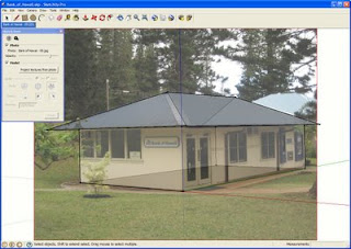
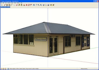
Let's say we just "matched" a great corner shot of the local bank and are satisfied with the geometry and texturing of the building. Well, almost satisfied -- there are those pesky trees and bushes on every face. Two new tools, Make Unique Texture and Edit Texture will make editing out the trees quick and easy.

First, we'll point SketchUp towards an image editor. In this example, we'll use Photoshop, but any editor will do. Another option is GimPhoto, a free, open source software download.
- Window > Preferences > Applications
- Choose the image editor of your choice.
- Select the face.
- Right-click and choose Make Texture Unique.
- Select the face.
- Right-click and hover over Texture.
- On the pop-out menu, select Edit Texture Image.
- The cropped texture will open in the image editor. Make your edits and save; the edited texture will update in SketchUp.

And voila! A clean, professional looking model.
If you want to submit a model to the 3D Buildings layer in Google Earth, we recommend removing any obstructions such as trees, people, and cars. While edited textures are not an explicit section of our Acceptance Criteria, it's certainly something we keep in mind when comparing two models of the same building.
Now that you know how to make models with obstruction-free textures, it's no surprise you're aching to start modeling. Check out the Help Model a City collections on the Google 3D Warehouse - with 15 different collections and almost 300 buildings ready to be modeled, there are buildings for modelers of every ability level. Each model file contains imported terrain, a sign post marking the intended building, and a description where you'll find a link to a Picasa Web Album with all of the photos you'll need.
Posted by Alex Juhola, 3D Data Specialist
可从此处完成的操作:
- 使用 Google 阅读器订阅SketchUpdate
- 开始使用 Google 阅读器,轻松地与您喜爱的所有网站保持同步更新
Wednesday, December 03, 2008
20 days, 9 hours...Xmas
参考消息 通过 Google 阅读器发送给您的内容:
With Thanksgiving dinner eaten and the calendar changed to December, it's officially the holiday season. And for the Geo team, that means it's time get ready to track Santa. Once again, Google has teamed up with NORAD to bring you the Santa Tracker, allowing you to follow Santa's path around the world with Google Earth and Google Maps. You can find all the details on the Official Google Blog.
Posted by Aaron Stein, Santa Tracker Team
可从此处完成的操作:
- 使用 Google 阅读器订阅Google LatLong
- 开始使用 Google 阅读器,轻松地与您喜爱的所有网站保持同步更新
Happier travels through Street View with Pegman
参考消息 通过 Google 阅读器发送给您的内容:
Today we're happy to announce some big improvements to the Street View feature in Google Maps! Thanks to feedback from our users, we've now made Street View even better and easier to use.
For one thing, Pegman, our plucky mascot, is now close at hand wherever you go. He hangs out right on top of the zoom slider:

To enter Street View, drag Pegman to a street (or just keep zooming in all the way, and the lowest zoom level is now Street View imagery). Tip: if you hold Pegman over a location for a second, you'll see a preview of what it looks like. Which direction you're facing depends on which side of the street you drag to:

Also, we've revamped the layout of Street View to give you more room for looking at really big stuff like the Colosseum in Rome, or for zooming in to get a better look at small stuff like this space invader mosaic in Paris.

The minimap in the corner lets you see the surrounding area. To see Street View and the map at the same time, you can click on the
Posted by Stephane Lafon, Software Engineer & Andy Szybalski, User Experience Designer
可从此处完成的操作:
- 使用 Google 阅读器订阅Google LatLong
- 开始使用 Google 阅读器,轻松地与您喜爱的所有网站保持同步更新


