Thursday, September 25, 2008
趣闻:俄罗斯人为Google Earth贡献了一张笑脸
参考消息 通过 Google 阅读器发送给您的内容:
Google Earth在全球广受欢迎,即使在仅有32%搜索引擎市场占有率的俄罗斯,也会有大批爱好者为她痴狂。
近日,俄罗斯小城Chelyabinsk民众自发组织起来,算准了为谷歌拍摄卫星图片的QuickBird经过小城上空时,摆出笑脸的阵势,让Google的卫星拍摄。
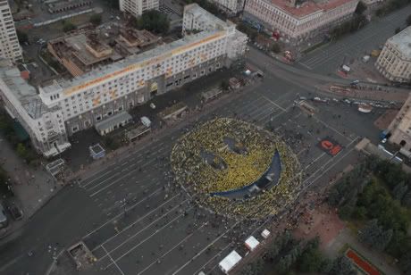
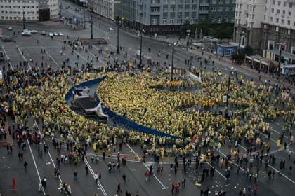
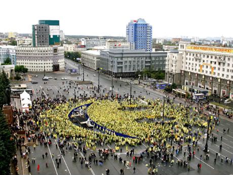


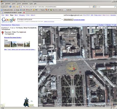
最后一张是一位网友截图到的,但我并不认为,这么快就可以上传到谷歌的服务器上,而我在谷歌的该地点地图卫星模式中,确实是未发现这张笑脸图片。
Copyright © 2008
×除注明外均为原创,若需转载或引用,请注明来自与G共舞·IT、本文链接及本声明.
[图文直播实况] [09年Google将推自有品牌]
[李开复:谷歌拼音输入法将应用于Gphone]
[Amazon将推出Gphone平台音乐商店] [图集欣赏]
[分析:G1能否带来手机革命?] [竞争对手的噩梦]
人家还要(相关)>>>
- 趣闻:印度饮料Go·gola (0)
- 趣闻:Google Bus(组图) (4)
- 八面来风(9月8日):谷歌浏览器在德国遭受尖锐批评 (3)
- 趣图:啊呀!撞上谷歌地图了! (2)
- 趣闻:谷歌Youtube XML蛋糕、谷歌厕所文化和雅虎搜索猴 (0)
- 趣闻:卸载谷歌浏览器 Google装可爱道歉 (9)
- 读者来信:Google Logo上太空 将拍摄最新地图图层 (0)
- 趣闻:Google猫 (2)
- 趣闻:谷歌计算器认为两个不同数相减等于0 (5)
- 谷歌地图中国版正式支持"卫星"视图模式 (13)

可从此处完成的操作:
- 使用 Google 阅读器订阅与G共舞·IT
- 开始使用 Google 阅读器,轻松地与您喜爱的所有网站保持同步更新
Wednesday, September 24, 2008
Find more, do more
Sent to you by 参考消息 via Google Reader:
On the Google Maps page, click on the "show search options" link on the right of the search box. Following this link will add a drop-down menu with options for refining your search. Choosing "user-created content" enables you to utilize the knowledge of local experts across the world.
So, after a long day on the water, you'll probably want to relax. Instead of renting a movie, explore the world via user-created content.
Lord of the Rings fan? Search for Lord of the Rings in New Zealand and find out such fan-tastic things as where the hobbits hid under the tree in the first movie to escape from the Nazgul.
Planning a trip down the Loch Ness river in the UK but was scared about a potential monster sighting? Search for monster near Loch Ness, UK and track where he has (allegedly) been and even what he looks like!
Planning an outdoor date? Searched for hikes in San Francisco. However, be sure to also check for any wildfires in San Francisco before heading out if you want there to be a second date.
Prefer dancing over hikes? Check out some awesome break dancing on the New York subway.
Try it out today and experience for yourself all the cool user-created content on Google Maps!
For a demonstration, check out this video for Seinfeld places in New York:
Posted by Courtney Lischke, Product Marketing Manager


Things you can do from here:
- Subscribe to Google LatLong using Google Reader
- Get started using Google Reader to easily keep up with all your favorite sites
想看外国地图?出国去!
Sent to you by 参考消息 via Google Reader:

前一段时间中国版本的Google地图加进了卫星地图,圆了不少人的模拟实地考察的心愿,但是要找中国以外的地方还是要转到世界地图上,谷歌地图中国版最近的一个更新就解决了这个问题,比如搜索"越南",在左侧的导航栏就会出现"查看世界地图"字样,点击后右侧的地图就会随之定位到越南,而域名已经是maps.google.com,此时,你已经在国外服务器上查询内容了。我刚才尝试了一下,在搜索具体的地名比如美国加州只是出现一些带有这个字样的中国的地名,而非美国地图,可见,谷歌目前还仅仅设定了国家级地名进行引导。我个人最期望在Google地图看到的功能是街景视图,何时能引进呢?
Copyright © 2008
×除注明外均为原创,若需转载或引用,请注明来自与G共舞·IT、本文链接及本声明.
[图文直播实况] [09年Google将推自有品牌]
[李开复:谷歌拼音输入法将应用于Gphone]
[Amazon将推出Gphone平台音乐商店] [图集欣赏]
[分析:G1能否带来手机革命?] [竞争对手的噩梦]
人家还要(相关)>>>
- 趣图:啊呀!撞上谷歌地图了! (2)
- 读者来信:Google Logo上太空 将拍摄最新地图图层 (0)
- 谷歌地图多项功能更新?更旧?! (2)
- 谷歌地图提供北京上海两地交通流量查询 (4)
- 谷歌地图中国版正式支持"卫星"视图模式 (11)
- 谷歌地图中国版推出搜索建议功能 (0)
- 谷歌地图:2008美国总统选举(Elections '08 Map Gallery) (0)
- 利用Google地图驾车环游世界 (6)
- 谷歌地图美国版增加图片、视频和热门搜索服务 (0)
- Google谷歌地图中国版上线"地表地形"模式 (5)

Things you can do from here:
- Subscribe to 与G共舞·IT using Google Reader
- Get started using Google Reader to easily keep up with all your favorite sites
在任何时间任何地点规划旅程 谷歌手机地图 2.2 版发布
参考消息 通过 Google 阅读器发送给您的内容:
我是加贝,今年刚刚大学毕业加入谷歌北京,从一名计算机系的学生成为了一名软件工程师。在北京生活了四年多,有一个很深的感触就是,这个城市好大,交通好复杂,以致于许多地方出租车司机也不知道怎么走。以前为了弄清楚如何出行,常常要花许多力气问路人,可是到头来,还是会坐错公交车,或者打出租车绕远路。后来我发现,我们可以通过谷歌地图,在电脑上规划好出行路线,然而这还是有一定局限性,因为我们需要有一台能上网的 PC;而今天,我们只需要一台手机,装上谷歌手机地图,就能够在任何时间、任何地点,为自己规划旅程。我刚刚加入 Google 就被这个看起来并不太复杂,但是真的为我们的生活带来了太多的便利手机应用程序吸引,毫不犹豫地加入了手机地图组。我们不久前发布了谷歌手机地图 2.2 版,现在让我们来看看这个新发布的版本为我们带来了什么功能:
我的位置——不需要高端的 GPS 手机,我们就能知道我们所处的大概位置。对于 GPS 手机用户而言,如果不需要精确定位,我们也能利用这个功能来避免漫长的 GPS 启动时间以及额外的电池消耗。
 

驾车路线——在手机上我们就能规划驾车行驶的路线,我们也会得知路程的总里程数,并且谷歌手机地图还支持跨城市的驾车路线搜索(例如可以搜索从漠河到三亚的路线)。
 

公交路线——我们能够在手机上搜索公交车换乘方案,并且能够预览行车路线。和 Web 版的谷歌地图一样,谷歌手机地图拥有全国 81 个城市的公交车/地铁数据。相信这能给经常依靠公共交通出行的用户们带来便利。
 

我们会继续努力,为用户们带来更多的帮助,希望大家从此不会在变得越来越大的城市中迷失方向!
可从此处完成的操作:
- 使用 Google 阅读器订阅Google 黑板报 -- Google 中国的博客网志
- 开始使用 Google 阅读器,轻松地与您喜爱的所有网站保持同步更新
Monday, September 22, 2008
Google谷歌数据中心分布图
了解更多
要了解更多信息请到了解数据中心查看这份非常棒的Google数据中心常见问题。
参考消息 通过 Google 阅读器发送给您的内容:
数据中心知识库 最近发布了一份Google数据中心常见问题 。和别的技术狂热分子一样我们Pingdm一帮人对这东西也非常的着迷。我们从中筛选了一些有趣的内容,并且利用其中提供的信息做了一份已知的投入使用的的和建设中的Google数据中心分布图。
Google数据中心分布图
如果把建设中的数据中心也包括进来Google在美国有19个数据处理中心,欧洲12个,俄国一个,南美一个,亚洲三个。Google专用的数据中心还不止这么多,有时候他们还会租用别的公司的数据中心的空间。
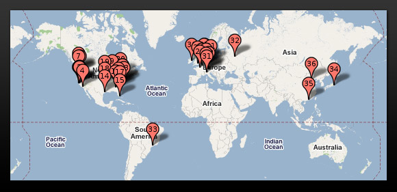
上图:Google数据中心世界分布图
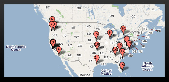
上图:Google数据中心在美国的分布图
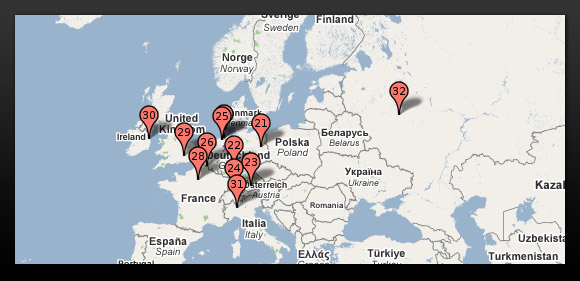
上图:Google数据中心在欧洲的分布图。
我们在Wayfaring创建了一份地图 ,你可以拖动浏览。
Google到底在数据中心上花多少钱?
根据Google收入报表来看2006年他们在数据中心的上支出为19个亿美金,2007年24个亿。
2007年Google披露了4个数据中心项目,每个的花费大约在6个亿,建筑,设备和电脑都包括在内。
Google数据中心的选址标准
- 大量的廉价电力
- 绿色能源。关注再生能源的。
- 临近河流或湖泊。他们需要大量的冷却用水。
- 大片的土地。更好的隐私和安全。
- 和别的Google数据中心的距离(数据中心的高速连接)
- 税收优惠

上左:Google的第一个投入使用的服务器。上中:坐落在俄勒冈州大峡谷的Google数据中心。上右:Google服务器机架特写。
下个会是什么?
Google已经开始在亚洲物色地点了,比如台湾和马来西亚。还有报道说立陶宛(东欧国家)可能会建一座。Google特别注意对美国的数据中心的保密,但是他们刚在南加州的Blythewood圈了466英亩地。
Google隐私
Google不轻易让人发现他们的数据中心的位置和数量。一大原因是几乎所有Google使用的IP地址都列在他们加州山景总部的地址下,因此只是看IP地址(IP关于哪里有谁的网络信息数据库或者IP地址数据库)根本无法了解他们的数据中心在哪,到底有多少。
除此之外Google还常常找一些别的和Google不搭界的公司组建数据中心,比如北加州的Lapis LLC,衣阿华的Tetra LLC。
Google一贯注意他们数据中心的保密性,因此我们呈现在这儿的信息基本上不会100%的正确。
了解更多
要了解更多信息请到了解数据中心查看这份非常棒的Google数据中心常见问题。
Copyright © 2008
×除注明外均为原创,若需转载或引用,请注明来自与G共舞·IT、本文链接及本声明.
人家还要(相关)>>>
- Lifehacker评选最佳软件 Google谷歌Picasa等四款入选 (0)
- Google Logo:保加利亚独立日(建国100周年) (2)
- Google Logo:秋分 (2)
- IT随笔:与G共舞为什么要关注有道? (6)
- 英国人才市场活跃提升Google文档的使用量 (0)
- Xippee:简化你的搜索 (1)
- Google Logo:伯利兹独立日 (2)
- Google谷歌跻身2008年度全球最佳品牌榜十强 (2)
- IT随笔:"Dream" of Google (0)
- Google谷歌完成在韩第一笔收购 力图扭转颓势 (0)

可从此处完成的操作:
- 使用 Google 阅读器订阅与G共舞·IT
- 开始使用 Google 阅读器,轻松地与您喜爱的所有网站保持同步更新
Saturday, September 20, 2008
Geo Education’s Alaska Trip Diary – Day 4
Sent to you by 参考消息 via Google Reader:
Kotzebue: guns, drugs and helicopters
Now that's an attention-getter! What kind of crazed situation did the Google Geo Education group get itself involved in? I'll get there soon enough, but first let me spend some time providing the back-story. Kotzebue consists of a little fewer than 4,000 people and is on the up-and-up, having gotten all of its roads paved within the past few years (the asphalt serves as effective dust control compared to the previous gravel-based roads). My entry into Kotzebue started stressfully enough, as our airline had left my luggage in Anchorage during our flight transfer. Although they said my bags would be on the following morning's flight into town, when our decommissioned yellow school bus, driven by Principal Dave, pulled into the airport at 7:30 am, no bags had come in and I was told they couldn't find them in their baggage system. Not the best mind-set to be in for teaching high school students.
As with our previous day in Barrow, our first moments at Kotzebue High School consisted of a mad scramble of getting online and setting up projectors, microphones and the Gigapan camera. Due to bandwidth limitations Anna and I had to change our hands-on My Maps-making lesson to more of a show and tell, but we had a great time searching for and mapping out the students' subsistence camps, where they go to hunt and fish with their families. Everyone posed enthusiastically for Gigapan photos in the library, sometimes switching seats as the camera panned around so they would appear two or three times in the image. The students were engaged and attentive, and asked great questions. Their behavior and aptitude for learning supported the results that the principal and his teaching colleagues have obtained, taking the school from a graduation rate of ~50% to greater than 85% in just eight years.
After class, Dave took us in the yellow bus to the local field office for the State of Alaska Department of Fish and Game. There we met wildlife biologist Jim Dau and learned about how his team tracks caribou migration patterns. Jim's dataset spans more than twenty years and consists of following radio-tagged caribou across the western half of Alaska. In the early days, researchers used to tag the caribou by shooting them with drug-tipped darts shot from a gun on a helicopter. Now they use boats and volunteer high-school students to reach the caribou in the water and safely tag them. Long story short, his team is very excited to get started using Google Earth in their research! Not a bad day after all.
Posted by Eric Kolb, GIS Specialist


Things you can do from here:
- Subscribe to Google LatLong using Google Reader
- Get started using Google Reader to easily keep up with all your favorite sites
Friday, September 19, 2008
Geo Education's Alaska Trip Diary - Day 3
Sent to you by 参考消息 via Google Reader:
En route from Barrow to Kotzebue
In order to get from Barrow to Kotzebue you need to fly all the way back to Anchorage first, so Wednesday was a travel day. We spent our layover refining our lesson plans, so I thought I would share the activity I've been presenting in classrooms this week. I call it "Our Changing World: Using Google Earth and KML imagery overlays to visualize change over time."
The Earth is a dynamic planet that is not static and changes frequently through landslides, volcanic eruptions, tectonic movements, weather patterns, and the changing of seasons. Visualizing these changes can be accomplished easily with Google Earth by using the "Imagery Overlay" tool to drape additional imagery information on top of the existing globe. The "UNEP: Atlas of our changing environment" layer in the Global Awareness folder has some great examples of these kinds of overlays.
My colleague Josie and I created a simple lesson plan using two imagery overlays from the Alaska Scenarios Network for Alaska Planning (SNAP) program which includes recorded average winter temperature data from 2000 to 2009, and estimated average winter temperatures for 2090 to 2099. Students will learn how to load an example dataset -- using the Keyhole Markup Language (KML) -- within Google Earth, and the skills needed to correctly place non-georeferenced data on the ground.

Figure 1: Starting positions of two imagery overlays. The 2090 – 2099 imagery overlay is incorrectly placed in the Gulf of Alaska. Students can move the overlay into the correct location.
Students will then be able to make their own investigations to visually compare where temperatures change in Alaska based on the recorded temperature values and estimates provided by Alaska SNAP.
 Figure 2: The two image overlays, correctly placed in the Alaskan borders, may now be used to visually compare average winter temperatures from 2000 – 2009 (left) versus estimated average winter temperatures in 2090 – 2099 (right).
 Figure 3: Students can use the Google Earth "Places" panel to activate each imagery overlay and make visual comparisons.
I also wanted to share the steps in how the Overlays KML can be used in your own class to demonstrate how imagery overlays are moved within Google Earth, and how these data may be used for visual interpretation of temperature data.
1) Download the Overlays.kml file to students' workstations.
2) Have students load Google Earth.
3) Have students type the word 'Alaska' in the "Fly To" search tab; they will be flown to the state and ready to load the imagery file.
4) Have students turn on the "Borders & Labels" Layer in Google Earth (if it's not already on) by checking the box next to the name.
5) Load the ImageryOverlayLesson.kml file into Google Earth by clicking "File" and "Open." Browse to the folder you saved it in and load the ImageryOverlayLesson.kml file.
6) A folder will be loaded into the Google Earth "Places" pane that looks like Figure 3. The Google Earth screen will now have a SNAP logo file and a temperature legend along the left screen edge, and two Alaska-shaped images will be visible on the globe. One image is in the correct location over Alaska while the second image is incorrectly located in the Gulf of Alaska.

7) Direct students to uncheck the box next to the "Average Winter Temperatures 2000 – 2009" layer (which displays the average winter temperatures recorded for January-March for 2000-2009) This will turn off the "correct" Alaskan imagery overlay and make it easier to move the second image correctly into place next.
8) Right-click on the "Estimated Average Winter Temperatures 2090 – 2099" layer (which estimates the average temperatures for January-March for 2000-2099) and select the "Properties" entry. A new dialog box will appear named "Edit Image Overlay" and a green box of lines will surround the image.

9) Move the Alaska image by clicking and holding the left mouse button and pushing the image into place. Release the left mouse button once the image is in place.

10) Use the other green lines surrounding the image to modify image height and width as needed.
11) Click the "Ok" button to exit "Edit Image Properties" window.
12) Direct students to uncheck the "Estimated Winter Average Temperatures 2090 – 2099" layer and check the "Average Winter Temperatures 2000 – 2009" layer.
13) Correlate colors on the temperature legend with values displayed in Alaska for the "Average Winter Temperatures 2000 – 2009" layer." Identify temperature regions for the state during winter.

14) Turn on the "Estimate Average Winter Temperatures 2090 – 2099" layer and compare the estimated values in 2090. Identify differences between this layer and the current "Average Winter Temperatures 2000 – 2099" layer.
 This lesson is specific to Alaska, but it's easy for teachers to find data relevant to their own geographic region, state, or city. I suggest looking at some of the KMLs in the Google Earth Gallery to find interesting data examples such as "World Oil Consumption" or a "Rising Sea Level Animation," or other examples available on the Internet such as Google Lit Trips or the National Snow and Ice Data Center Virtual Globes Gallery. These example KML files could be integrated into existing lesson plans or used as the basis for new lesson plans. Some possible lesson plan integrations include:
 - Identifying site locations for literature studied in class to place a story in context to the surrounding geography of an area – example includes "Candide" from Google Lit Trips (Hyperlink).
- Tracing seasonal animal migrations between regions – example birds flying South for winter and returning in the Spring.
The flexibility of KML allows creative integration possibilities for teachers in normally non-spatial topics, and can further enhance students' learning experience of the world around them locally and globally.
Our flights from Barrow to Kotzebue, AK were very smooth and gave us plenty of time to discuss changes to our lesson plans and how we can better share information with students in Kotzebue. I look forward to visiting Kotezebue, AK and continuing our Geo Education adventure.
Posted by Jason Cain, Geo Education Team


Things you can do from here:
- Subscribe to Google LatLong using Google Reader
- Get started using Google Reader to easily keep up with all your favorite sites
Tuesday, September 02, 2008
Google Earth/Maps上也看不到的50个重要地点!
所有这些,功能不可谓不强大,然而技术上再强大的工具也会受到政府规章,个人隐私和法律规章的限制,因此Google Maps并不是万能的。
以下我们将列举Google Maps上看不到的地点:
 |
| 图 谷歌卫星地图 |
政府和军事设施
1. 白宫:在Google Maps上找到的关于白宫的图像经过了电子模糊化处理,目的是将部署在这里的防空和安全设施图像模糊保证白宫的安全。
2. 美国国会:从Google Maps开始出现的那会,国会山的图像就是模糊的。现在的Google Maps 和 Google Earth展示的仍是以前的老照片。
3. 切尼的住所:应美国政府的要求,这位美国副总统的住所的照片被模糊化了。尽管在Google Maps找不到高清图片,但是在其它网站上可以找到一些高清晰的照片和航拍图。
4. 荷兰的索斯特布尔格空军基地:这个荷兰空军基地以前曾是冷战时期美国空军F-15战机大量存在的地方。
5. 位于马萨诸塞州科德角的PAVE PAWS:这一地方的独特之处在于其是美国空军太空司令部的导弹预警和太空监测雷达系统的所在地。除了科德角这一雷达系统之外,在其他地方也部署了两套系统。
6. 伊拉克巴士拉的沙特阿拉伯酒店:据说这一地点被屏蔽是因为发生在这里的袭击英国人的恐怖分子正是利用了Google Earth做到了目标的瞄准。据说是如此。
7. 荷兰皇家空军训练基地:这个城市是荷兰皇家空军的主要训练基地,也是北约组织联合命令中心的一部,还是北欧空军联合体的三个亚区域作战指挥中心之一。
8. 法国兰斯空军基地:这栋位于兰斯空聚基地唯一建筑被屏蔽了。
9. novi sad军事基地:这个军事基地位于兰斯拉夫
10. Kamp van Zeist基地:前美国空军基地,英国所有。2000泛美航空支队的轰炸实验曾在这里进行。
11. 北约组织的C3 Agency:位于比利时布鲁塞尔,为北约的C4ISR系统(咨询,命令,控制,通信,情报,监视和搜索)提供技术和资金支持。
12. 新的美国大使馆
13. 北约组织空军基地Geilenkirchen:这是北约组织空中早期预警系统机E-3A的主要基地。主要是为提高北约组织空防能力提供早期雷达预警。这个基地包括包括17架为空中监视和空中通信提供支持的E-3A预警机。军事人员来自于14个国家。
14. 德国的Ramstein空军基地:Ramstein空军基地这里是美军第86航空运输大队和美国空军欧洲的总部。这也属于北约。也是多个国家的军事人员在这里工作。
15. 位于荷兰的皇家马车队:主要是为皇室成员提供交通服务
16. Huis Ten Bosch宫殿:荷兰皇室的四个专属宫殿之一,位于海牙。
17. Fortress on Castell de Montju?:位于西班牙巴塞罗那,以前曾是军事基地,虽然Google Maps上找不到照片,2008年的Google Earth却可以找到相关高清图片。
政治因素对谷歌卫星地图影响还在继续
18.迈阿密北部橡树城:2008年六月下旬,这个城市郊区的居民成功地要求从Google Map上移除了自己的街区图像。这一要求由当地的4500名居民集体提出。Google的发言人称,现在不知道还有哪些城市也有类似的要求。
19. Bahrain:2006年,Bahrain的信息部指示国家网络禁止访问Google Earth服务器。这一禁令持续了三天。网上传言,之 所以实施禁令的原因是为了防止穷人看到富人住宅之后产生的不满情绪,从而达到掩盖财富分配不均的事实。网上有人发布了当时的截图照片。
20. 欧洲:2008年五月,欧盟数据保护机关抱怨Google Maps的街道全景功能展示了美国30个城市360°的全景照片,而这个功能在欧洲的使用会侵犯欧盟的隐私法。
21. 新加坡:2008年4月,Google和新加坡国土资源部关于版权的纠纷得到解决。新加坡国土资源部宣称Google的地图完全是照搬其产品。所以GoogleMaps在新加坡被禁止使用。
22. 苏丹:Google Earth在苏丹遭遇噩运主要是因为美国政府对苏丹的经济制裁。在Google Earth加入了关于苏丹人道主义危机的信息之后,受到了更加广泛的禁止。
23. 伊朗:2007年,一位伊朗商人正打算下载Google Earth的时候发现弹出的页面显示:"感谢您的关注,但是您要下载的产品在贵国已被禁止。"
24. 印度:Google审查了印度的敏感地点。因为前总理卡拉姆曾表达了对这些高清图片的关注。
25. 澳大利亚悉尼:悉尼内城的绝大部分都被屏蔽了。Google称出现这种状况的原因是图片提供商出现了一点问题,但是知情者指出主要是担心恐怖袭击。被屏蔽的地点包括国会,澳大利亚国防部等。
26. 东南亚:被Google Earth屏蔽的区域包括中国的新疆和西藏自治区,巴基斯坦北部及皇宫。
27. 太平洋关岛上的Yona村:不知道什么原因被屏蔽。
28. 荷兰乌德勒支市:有人说该书的屏蔽只是一个失误,但是我们无法否认这个城市作为荷兰宗教中心与此事的相关性。
核电站和发电站
29. Seabrook核电站:这个核电站位于新汉普郡,是世界上最早的核电站之一。
30. 阿莫斯和研究反应堆:这个实验室的主要研究室反应堆物理学,和调试。从1974年以来,大概有1兆瓦的核能在此运行。
31. 纽约文斯切斯特Indian Point Energy Center(印度点能源实验室):这是一座包括3台发电机组的核电站。
32. 纽约尼亚加拉瀑布大坝和相应的砸门:这是重要的水电站
33. McGuire核电站:它使用了两台西屋公司的水冷反应堆,足以产生2200兆瓦特的核电,展整个北加州核电的一半电量。
34. Perry核电站:不知道为什么被屏蔽
35. Oconee核电站:位于南加州,使用三台水冷反应堆,是美国第二大核电站,受美国核电管理委员会直接管理
36. 马萨诸塞州油罐农场:存储了大量液体化学物质
37. Shoreham核电站:尽管从1989以来就处于关闭状态,但是依然被屏蔽
38. 马萨诸塞州切尔西市的液化天然气管道以及波士顿的一个大型工业港口:
39. 马歇尔煤电站:位于北加州的包括四台机组的大型煤电站。
大学和研究中心
40. 麻省理工林肯实验室:林肯实验室受联邦资助,主要是利用先进技术帮助解决国家安全中面临的问题
41. 通用电力世界研究实验室和纽约通用电力主发电机组:在通用电力的官网简介上,这个研究中心拥有世界上"最聪明的3000名研究人员"。
42. Knolls原子能源实验室:这个研究机构支持海军核动力推动计划,主要是帮助研究,设计,规划,操作和管理美军的核战舰。
43. 石溪大学:因为布鲁克海文国家实验室在校园内
44. 曼哈顿威尔大学的Dammann 和Tenney宿舍:可能是因为其靠近多家公司总部的原因,包括百事,德州能源和万事达卡公司。
45. Noordwijk Aan Zee:欧洲太空研究和技术中心(ESTEC),也是位于荷兰的欧洲太空研究署(ESA)的一部分。
46. 高频电磁波研究计划(HAARP)天线分布:位于阿拉斯加和加拿大育空地区边界:属于HAARP计划的一部分
47. 白平原火车站(White Plains):在维基百科上写着:"由于安全原因,在Google Maps 或Google Earth找不到相关图片。"
48. William Hurt(威廉姆.赫特)的家:位于巴黎郊外
49. Playland游乐园:位于纽约
50. 火奴鲁鲁圣路易斯学校:在Google上只能找到足球场,训练场馆,体育场和跑道。
51. Boring(博林)家的房子:博林控告Google Earth上的图片侵犯了其隐私,并且带来了很大的精神压力。
--
鹅是一个兵,来自老百姓
鹅不是老大,天才是老大
您无所不谈,鹅也不例外
鹅是参考消息@无所不坛
janadabc.blogspot.com
google.com/group/go2group