Sunday, August 31, 2008
Empowering users to map their worlds增强用户绘出自己的世界
Sent to you by 大拿家 via Google Reader:
This need inspired us in Google India to design and build Google Map Maker, which enables users everywhere over to create rich, deep maps and fresh local data. People can mark their favorite spots in their cities and hometowns, add features such as roads, parks, and buildings, tag small businesses to help users find them, and collaborate to map neighborhoods of interest. This product is motivated by the spirit of information democracy, where people can create information that are moderated and consumed by their peers.
Today, we are bringing home this innovation by launching Google Map Maker in India, which has already been deployed in 57 other countries.
We hope Google Map Maker will result in rich local data which will benefit Google users both on the web and on mobile. The creation of base maps where there were previously none will encourage many mashups, mapplets and other cool applications that make use of this data. We're also excited to see Google Map Maker create a new breed of local map experts who bring their passion for their neighborhoods and communities into the online world, adding to local commerce, tourism and investment.
I will leave you with a map of IIT Bombay, the alma mater to many of us in Google India. When I spent a few hours mapping IIT Bombay -- the place I lived in, the school I went to, and the streets I played on, it turned out to be a surprisingly satisfying experience that reconnected me to a place that is home to many of my memories. We hope you will find the Google Map Maker experience as fun and fulfilling as we do.

Posted by Lalitesh Katragadda, Software Engineer and creator, Google Map Maker


Things you can do from here:
- Subscribe to The Official Google Blog using Google Reader
- Get started using Google Reader to easily keep up with all your favourite sites
GeoEye将向Google地球提供41厘米精度地面照片
人民网 - 7小时前
北京时间8月29日消息,地眼(GeoEye Inc)在周四宣布,它已经与谷歌签订了合作协议,它将在9月4日宇宙飞船发射后为谷歌地球和谷歌地图提供其地眼1号卫星拍摄的高清晰 ...
俄罗斯一箭发射5颗德国卫星 新华网 - 2008年8月29日 新华网莫斯科8月29日电(记者聂云鹏)据俄塔社报道,俄罗斯29日用一枚"第聂伯"运载火箭发射5颗德国地球探测卫星。 俄塔社援引俄军方发言人沃夫克的话说,这枚 ... |
Google将获得41厘米精度卫星照片 北方网 - 8小时前 Google已经与GeoEye卫星公司签约,将获得后者提供的精度达41厘米的超清晰卫星照片,而这也将是迄今为止商业公司所能提供的最精细的卫星图像。 ... |
GeoEye将向Google地球提供41厘米精度地面照片 搜狐 - 2008年8月28日 【搜狐IT消息】北京时间8月29日消息:据国外媒体报道,周四,地眼(GeoEye)公司宣布,已经和Google签约,将把即将发射的新卫星获得的高清照片提供给Google地球。 ... |
育碧与卫星照片公司联手打造[HAW IT世界 - 2008年8月28日 育碧昨日宣布将利用GeoEye的IKONOS地球影像卫星为旗下空战作品《汤姆克兰西之鹰击长空》(Tom Clancy's HAWX)提供地貌实景素材。 GeoEye的IKONOS是世界上首个提供高 ... |
--
鹅是一个兵,来自老百姓
鹅不是老大,天才是老大
您无所不谈,鹅也不例外
鹅是参考消息@无所不坛
janadabc.blogspot.com
google.com/group/go2group
Friday, August 22, 2008
Google Releases Geolocation Features for Ajax API, Gears
Sent to you by 参考消息 via Google Reader:
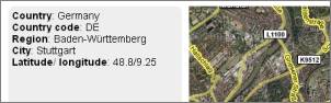
Google provides a neat new way for you to grab the user's location information via JavaScript. It's the ClientLocation property of their Ajax API. All you need is a free API key, and then you can load their JavaScript file in your HTML, and access the properties city, country, country code, region, and latitude/ longitude (where available, that is – the values may not always be found by Google, and Google disclaims they are only "approximate"). With this information in hand you can then feed it back to other services, including the Google Maps API, or say an image search for the city name – take a look at the example page called "Where are you?" I've created. The only thing officially missing seems to be a server-side way to access the geolocation data.
In other geolocation news, Google released a Geolocation module for their Gears API. Google in their blog post on this says the data returned here is more precise than what the Ajax API delivers, as it "can use the cell-ID of nearby cell towers or on-board GPS (if either is available)". However, for this to work users need to have the Google Gears plug-in installed on either their desktop or their mobile system.
Google continues trying to make their open-sourced Gears more useful to web developers, but what's in it for them? Well, the more useful Gears becomes as a plug-in the more likely it will be pre-installed on systems in the future – which increases the control Google has over the browser environment, which in turn enables them to more quickly launch initiatives which make the web in general and their tools more powerful without the need to go through years of industry lobbying/ standardization/ browser updating & deployment processes. As with other initiatives in which Google tries to speed up deployment of frameworks which hold the power to benefit them, the Google branding is de-emphasized here. For instance, you won't find a big Google logo on the Free the Airwaves homepage, the Android homepage, the Open Handset Alliance, or the OpenSocial blog, even when Google is either owner or major party in these projects. And take a look at how the Gears project changed its name and logo from "Google Gears" to just "Gears" over time (while adjusting the motto from "Enabling Offline Web Applications" to the more general "Improving Your Web Browser"):
![]()
Google's boss Eric Schmidt is a self-proclaimed Machiavelli fan, and Machiavelli once posed the question of whether for a leader it's better to be feared or loved. I think Google answered the question for themselves: in today's free-roaming web environment, it's clearly much better for them to be loved.
[Via Reto.]
[By Philipp Lenssen | Origin: Google Releases Geolocation Features for Ajax ... | Comments]
[Advertisement] Google books at eBay: background info on Google, AdWords, AdSense, Blogger and more...

Things you can do from here:
- Subscribe to Google Blogoscoped using Google Reader
- Get started using Google Reader to easily keep up with all your favorite sites
Google中国地图新增实时交通流量信息
Sent to you by 参考消息 via Google Reader:
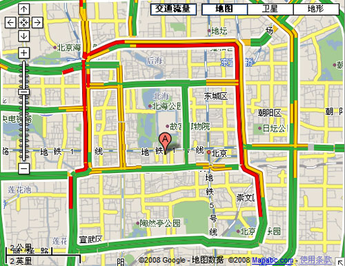
中国版的谷歌地图已经悄然更新了北京和上海的地图,新增加城市公路的实时交通信息,使用户在制订驾车路线时做到心中有数。
目前,在中国开通实时交通流量的Google地图城市只有北京和上海,Google的交通流量信息服务为主要的城市公路提供交通状况信息:绿色表明不堵塞;黄色表示有轻微的拥挤;而红色表明道路相当堵塞。
据Google产品经理介绍,这些交通数据信息来自几个途径,包括道路监控头,汽车和出租车的反馈信息。因此,有时会出现信息数据不够的情况。
Google暂时只为城市主要的公路提供路况信息,但最终可能会将这项服务扩展至全部的道路。之后,这项功能还可能会扩展到中国其他主要大城市。这样,驾车用户在出行的时候就更方便了,比起交通电台来说,Google地图的交通流行信息更为直观和清晰。
继续阅读《Google中国地图新增实时交通流量信息》的全文内容...
相关文章:

Things you can do from here:
- Subscribe to 月光博客 using Google Reader
- Get started using Google Reader to easily keep up with all your favorite sites
谷歌地图提供北京上海两地交通流量查询
Sent to you by 参考消息 via Google Reader:
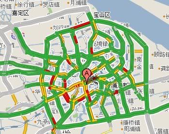
近日,谷歌地图新增加了北京和上海两地的交通流量查询,这项服务是由mapabc提供的,增加的图层也是直接使用mapabc的。
当用户的地图显示进入北京和上海地域时,谷歌地图就会在"地图、卫星、地形"这三个功能按钮左侧,显示"交通流量"的按钮,用户点击这个按钮,就会显示及时的交通流量信息,其中红色表示拥堵,黄色表示较拥堵,而绿色表示畅通,灰色为暂时没有该路段的数据。
我查看了自己较熟悉的上海的路段,发现,谷歌地图的交通流量服务已经覆盖了上海的主要路段,连延长西路这样的一来一去的小路也有数据。驾驶员每天出门前看一眼,还是有不少帮助的。不过说实在的,就像老司机不用听交通台一样,熟悉路段的司机也不会来谷歌地图看交通流量了。
发现一个bug,当展示天津地图时,谷歌也会提示有交通流量服务,但事实上并没有这项数据,估计是谷歌把北京的区域划得太大,把天津也划进去了的缘故。此外,mapabc还提供广州的交通流量,但谷歌地图目前没有提供这项服务,so奇怪。
Copyright © 2008
×除注明外均为原创,若需转载或引用,请注明来自与G共舞·IT、本文链接及本声明.
人家还要(相关)>>>
- 谷歌地图中国版正式支持"卫星"视图模式 (10)
- 谷歌地图中国版推出搜索建议功能 (0)
- 谷歌地图:2008美国总统选举(Elections '08 Map Gallery) (0)
- 利用Google地图驾车环游世界 (6)
- 谷歌地图美国版增加图片、视频和热门搜索服务 (0)
- Google谷歌地图中国版上线"地表地形"模式 (5)
- Google谷歌地图增加维基百科内容 (0)
- Google谷歌是上海网民的首选搜索引擎 (5)
- Google谷歌即将推出手机地图客户端版 (7)
- 地图服务网站还是围绕地图做服务?(Google入乡随俗41) (0)

Things you can do from here:
- Subscribe to 与G共舞·IT using Google Reader
- Get started using Google Reader to easily keep up with all your favorite sites
Tuesday, August 19, 2008
谷歌地图中国版正式支持“卫星”视图模式
Sent to you by 参考消息 via Google Reader:
![]() 谷歌地图在美国十分流行,而在中国,限于法律的约束,有很多重要的功能无法在大陆地区推出,谷歌一直在为此进行公关。今年三月,谷歌低调推出了地形模式功能,今天,与G共舞读者Marcher来信提醒说,在谷歌地图中国版(http://ditu.google.cn/),已经可以使用"卫星"视图模式查看Google Earth的卫星地图。
谷歌地图在美国十分流行,而在中国,限于法律的约束,有很多重要的功能无法在大陆地区推出,谷歌一直在为此进行公关。今年三月,谷歌低调推出了地形模式功能,今天,与G共舞读者Marcher来信提醒说,在谷歌地图中国版(http://ditu.google.cn/),已经可以使用"卫星"视图模式查看Google Earth的卫星地图。

用户可通过选择右上角的"卫星"来显示卫星图片

谷歌地图卫星模式效果:上海体育场
在之前几天,搜狗地图推出了中国国家测绘局官方版本的卫星服务,但是说实话,质量并不如谷歌版本的,只是有提示道路名称,不会让浏览者看着迷路,这不错。目前,使用谷歌卫星地图,可以先在普通地图模式查找好,然后切换到卫星模式,这样会好一些。

谷歌卫星版东方明珠

搜狗卫星版东方明珠
谷歌卫星地图中国版的推出,对于广大网友和谷歌而言都是一个好消息,虽然功能还无法与国际版本接轨,但毕竟是一个很好的信号——谷歌开始深耕于中国市场了。
Copyright © 2008
×除注明外均为原创,若需转载或引用,请注明来自与G共舞·IT、本文链接及本声明.
人家还要(相关)>>>
- 视频:中国军事专家论谷歌地球探索(Google Earth) (6)
- 谷歌地图中国版推出搜索建议功能 (0)
- 谷歌地图:2008美国总统选举(Elections '08 Map Gallery) (0)
- 索尼将升级PSP固件 新增谷歌搜索功能 (1)
- 利用Google地图驾车环游世界 (6)
- Google地球简体中文版即将上线 (5)
- 谷歌地球探索(Google Earth)支持网页浏览器浏览(视频) (2)
- 5·12四川大地震谷歌地球探索地标文件 (0)
- 谷歌地图美国版增加图片、视频和热门搜索服务 (0)
- Google谷歌地图中国版上线"地表地形"模式 (4)

Things you can do from here:
- Subscribe to 与G共舞·IT using Google Reader
- Get started using Google Reader to easily keep up with all your favorite sites
Tuesday, August 12, 2008
Where is Georgia on Google Maps?格鲁吉亚在哪里
Sent to you by 参考消息 via Google Reader:
The recent conflict in Georgia has raised some questions about how Google Maps has handled mapping in that part of the world. The most obvious question is, why doesn't Google Maps show any cities or roads for Georgia, or its neighbors Armenia and Azerbaijan? The answer is we never launched coverage in those countries because we simply weren't satisfied with the map data we had available. We're constantly searching for the best map data we can find, and sometimes will delay launching coverage in a country if we think we can get more comprehensive data. Some of our customers have asked if we removed map data from any of these countries in response to the recent hostilities in that region and I can assure you that is not the case. Data for these countries were never on Google Maps in the first place.
But this has generated a lot of feedback that we are listening to and learning from. We're hearing from our users that they would rather see even very basic coverage of a country than see nothing at all. That certainly makes sense, and so we have started preparing data for the handful of countries that are still blank on Google Maps. Georgia, Armenia, Azerbaijan, as well as other significant regions of the world will benefit from this effort.
In the meantime, much of this data, including cities in Georgia and other surrounding countries, can be found in Google Earth.
Posted by Dave Barth, Product Manager


Things you can do from here:
- Subscribe to Google LatLong using Google Reader
- Get started using Google Reader to easily keep up with all your favourite sites
Friday, August 08, 2008
Google Maps上的北京2008奥运会
Sent to you by 参考消息 via Google Reader:
据Google Latlong报道,随着2008夏季奥运会在北京的正式举行,Google Maps已经更新了北京地区的卫星地图,并详细添增了双语地图在上面,并使用Google sketchup建立了一个三维体育场。
此外,今天Google还在Google Maps上发布了一个2008奥运会网页(中文版),这是一个一站式的奥运更新的页面,包括奥运奖牌排行、比赛项目时间和结果、场馆卫星地图等等。
点击"奖牌",可以看到各个国家的奖牌统计,点击"赛事",可以看到各项比赛的时间、国家和场馆,所有的数据都是来源于世界新闻通讯社的官方资料。
对于iGoogle的用户,可以点这个页面(中文版)将其添加到iGoogle个性化主页中。
总的来说,Google在北京奥运会的资料发布上可算下足了功夫,做的事情还真不少。

继续阅读《Google Maps上的北京2008奥运会》的全文内容...
相关文章:
Things you can do from here:
- Subscribe to 月光博客 using Google Reader
- Get started using Google Reader to easily keep up with all your favourite sites
Thursday, August 07, 2008
Off to the Games!
Sent to you by 参考消息 via Google Reader:


Posted by Brittany Bohnet, Google Maps Special Projects


Things you can do from here:
- Subscribe to Google LatLong using Google Reader
- Get started using Google Reader to easily keep up with all your favourite sites