Wednesday, July 30, 2008
Google Maps Power to the print
Sent to you by 参考消息 via Google Reader:
Google Maps can help get you where you want to go, but let's face it, you can't be online all the time. Sometimes you really just need a good old-fashioned hard copy, so we're making it easier to print exactly the information you want: text directions, maps for any step, and - for the first time - Street View images.
 Unfamiliar with the area? You can turn on a full-size overview map for your entire route and specific maps for each step.
  Chances are, however, that you don't need that much detail for every single step, so hover directly over each step to turn that map on or off.
 You can turn on all available Street View images by selecting the "Street View" option at the top of the page. Or, you can hover over any step to see if Street View is available for that particular location, then click the "Street View" link to turn on the image for that step. If you want more control over the final print-out, simply grab and pan the image to reveal other landmarks - your Street View image will be printed at the viewing angle of your choice.
Now that we've arrived safely at our hotel, let's head uptown to the Natural History Museum. A printed map of the area with an image of the entrance might help us orient ourselves when we're on the street and away from the computer. Just pan your map over to the museum, and find the entrance in Street View. Click "Print" above the map to open the preview window. Finally, customize the layout to add or remove the map, and pan the Street View image to show exactly what you want. Print, pack and enjoy!


Things you can do from here:
- Subscribe to Google LatLong using Google Reader
- Get started using Google Reader to easily keep up with all your favorite sites
Google Maps改版,支持中国地图
Sent to you by 参考消息 via Google Reader:
Google Maps今日进行了大改版,对于中国用户来说,这次改版最重大的意义在于,Google Maps国际版首次加入了中国的传统地图的地理交通信息,首次将交通地图和卫星地图整合在一起,使用户使用更为方便,使用地图所带来的信息和价值大为提升。
另外,在Google Maps国际版中,中文也得到了完美的支持,中国用户访问Google Maps后显示的为全中文界面,搜索中文关键字会显示出商户的信息,如下图所示。

对比下面的中国版的谷歌地图,除了域名和左边的内容信息不同之外,地图显示的信息完全相同。

同样,在Google Maps中点"卫星"可以看到刚才界面的卫星地图,但是我发现,两者在坐标上有不少差别,地理位置并不能完全吻合,误差至少有几十米左右,如下图所示。

这个新版的Google Maps出来之后,昨天所说的搜狗卫星地图的优势就荡然无存了,因为现在Google Maps在中国也能传统地图卫星地图共同显示了,虽然坐标还有点误差,但相信Google稍后会修正这些错误的。
继续阅读《Google Maps改版,支持中国地图》的全文内容...
相关文章:

Things you can do from here:
- Subscribe to 月光博客 using Google Reader
- Get started using Google Reader to easily keep up with all your favorite sites
Tuesday, July 29, 2008
搜狗推出卫星影像地图
Sent to you by 参考消息 via Google Reader:
据搜狐网报道,搜狗地图正式发布"搜狗卫星影像地图"服务。据了解,这是目前国内第一个应用了最新数据的卫星图片产品,首次发布21个城市的高清晰影像服务,其中涵盖全部七个奥运城市。
据搜狐网介绍,使用搜狗卫星影像地图无需下载,打开网页版搜狗地图即可自由切换。通过搜狗地图提供的卫星影像服务,使用者可以清楚地看到地面上的建筑、汽车、树木,甚至是道路上的标线,据知情人士介绍,"最高分辨率达到了0.5米/像素,已经是世界商用卫星图片服务的极限。"通过这项服务,网民甚至可以轻易地分辨出地上的小汽车是二厢车还是三厢车,更可以快速寻找到自己家的屋顶。在搜狗卫星影像服务中,用户依然能够进行地图搜索的相关操作,诸如放大缩小图像、对位置进行临时标注、测距、截图,还可以随时与传统地图切换,使用公交、自驾线路查询等基本功能轻松指引出行路线。

根据我的使用观察,搜狗卫星地图的数据实际来自DigitalGlobe,在其地图上有DigitalGlobe的标志。DigitalGlobe是高分辨率影像领域的全球商业化领导者,同时也是Google Earth的卫星影像提供商,DigitalGlobal拥有3颗成像卫星:Worldview I、Worldview II 和 QuickBird。这些卫星能够搜集高分辨率的商业地球影像,比其他所有的商业化卫星都能提供最大尺寸、最大在线存储量和最高分辨率的影像。Google Earth卫星地图的影像就是由DigitalGlobe的QuickBird等卫星拍摄,其图像清晰度非常高。这次搜狗推出的卫星地图,我估计也是通过购买DigitalGlobe的卫星图像来实现的。搜狗卫星地图和Google Earth所不同的是,搜狗直接在地图上标记了部分街道、桥梁、楼宇的名称,但目前没有发现用户交互式标记的功能,预计搜狗也不会开放这样的功能给大众。
目前我浏览的过程中发现,搜狗卫星地图只支持中国主要大城市的地图,偏远地区(例如某些敏感的军事基地)不提供卫星地图,也不提供中国以外国家的卫星地图,属于一个自娱自乐的和谐版卫星地图。
相关文章:
Things you can do from here:
- Subscribe to 月光博客 using Google Reader
- Get started using Google Reader to easily keep up with all your favorite sites
Saturday, July 26, 2008
视频:中国军事专家论谷歌地球探索(Google Earth)
Sent to you by 参考消息 via Google Reader:
谷歌地球探索软件(Google Earth)能威胁谁?谷歌地球探索是一款由谷歌公司开发的虚拟地球软件。2005年6月,谷歌地球的推出让所有用户都体验到了那种震撼的感觉,通过谷歌地球,你可以浏览全球范围内任何一处地点的高清晰度卫星照片,甚至还可以从中找到自家屋顶……央视国际频道邀请中国安全专家讨论谷歌地球探索的利与弊。
P.S. 我被那个专家为谷歌地球探索找到的盈利模式雷到了……(22分30秒之后)
Copyright © 2008
×除注明外均为原创,若需转载或引用,请注明来自与G共舞·IT、本文链接及本声明.

人家还要(相关)>>>
- 谷歌中国移动搜索官方卡通推广视频:小谷哥哥变身 (2)
- 索尼将升级PSP固件 新增谷歌搜索功能 (1)
- 谷歌推出网站优化工具(Google Website Optimizer) (6)
- Google地球简体中文版即将上线 (5)
- Youtube推出欧洲杯(欧锦赛)专题频道 (0)
- 谷歌地球探索(Google Earth)支持网页浏览器浏览(视频) (2)
- 5·12四川大地震谷歌地球探索地标文件 (0)
- 谷歌地图美国版增加图片、视频和热门搜索服务 (0)
- Google谷歌中国网页搜索整合视频截图 (0)
- Google谷歌的俄罗斯版Gmail宣传视频 (1)

Things you can do from here:
- Subscribe to 与G共舞·IT using Google Reader
- Get started using Google Reader to easily keep up with all your favorite sites
Tuesday, July 22, 2008
Google Earth高级程序员辞职 称Google规模过大
蒂里在博客中写道:"过去数年中,我一直从事同一种产品开发.我很怀念最初在一家小型创业公司工作的时光.目前Google开发团队规模已经很大.我离职 的原因很简单:就是想换一下工作环境.虽然我对Google存有很美好的记忆,但今天的 Google已经与数年前大为不同."
蒂里表示,自己准备先到欧洲休假一段时间,然后再到一家主营虚拟现实(virtual reality)服务的小型公司任职.他在周四的博客还披露,在他加盟Keyhole之前,该公司运营情况已难以为继,手下员工连工资都拿不到.但美国政 府于2003年3月底发起伊拉克战争后,美国有线电视新闻网(CNN)首先使用了Keyhole产品,此后Keyhole才逐渐获得了外界关注.
蒂里还透露,在Keyhole发展初期,美国中央情报局(CIA)是该公司的主要资金援助人.时至今日,CIA也是Google Earth的大客户之一,但CIA对Google Earth开发的影响力正日益减弱,原因是CIA所提供的资金对Google来说已可有可无.
--
鹅是一个兵,来自老百姓
鹅不是老大,天才是老大
您无所不谈,鹅也不例外
鹅是参考消息@无所不坛
janadabc.blogspot.com
http://groups.google.com/group/Go2group
Monday, July 21, 2008
Summer camp, Google Earth style!
Sent to you by 参考消息 via Google Reader:
Last week, 18 Googlers brought their 9-12 year old kids to our Mountain View headquarters to spend their week learning with Google Earth and all the other geo tools. By the end of the week, the "Geo Camp" participants had mastered Google Earth, Maps, and Docs, and used these tools to research environmental issues, virtually tour the planet (and universe), and collaborate to build sophisticated presentations on habitats around the world.
 I'm not sure who had more fun -- the teachers or the kids! As the week came to a close, we asked them all to reflect back on what they had learned, and I just can't help but share some of their responses:
I didn't know I could ____ with Google Earth
- fly (Matt, 6th grader)
- see all the rides at Disney World (Gwen, 4th grader)
- learn about endangered animals (Aditya, 7th grader)
- the Space Needle (Jack, 7th grader)
- the Empire State Building (Jake)
- the entire universe (Andrew, 6th grader)
- find a place to go on vacation (Nick, 5th grader)
- share global awareness about different countries to other people (Esha, 9th grader)
- look at other galaxies, and see if there's traffic (Aditya, 7th grader)
- build more SketchUp buildings (Erik, 5th grader)
- create a ship simulator in which you could be the captain of a ship (Ashna)
- make a driving feature so people could pretend to drive on roads (Warren, 7th grader)
Posted by Tina Ornduff, Google Earth Education team


Things you can do from here:
- Subscribe to Google LatLong using Google Reader
- Get started using Google Reader to easily keep up with all your favorite sites
Monday, July 14, 2008
Google使用“间谍车”偷拍整个英国
Sent to you by 大拿家 via Google Reader:
据英国《每日电讯报》7月11日报道,"谷歌地球"(Google Earth)出动"间谍车",在英国各处秘密拍摄一条条街道和成百上千的英国家庭门前照片,并将它们放在网上,建立一个名为谷歌"街景地图"(Street View)的网站。该计划去年已经在美国进行,其目的是准备在全球推行,但是该计划被媒体和一些专业人士谴责为"完完全全的侵犯隐私行为"。
据介绍,"街景地图"网站将会使世界上任何一人随便输入一个英国的地址或是邮编,通过点击屏幕上的箭头就能立马看到一张360度的街头图片,还会包括建筑物、汽车以及人群的特写镜头,显示出人们进出医院、保健诊所、成人商店以及酒店的情景。 用户就像是亲自行走在大街上,并且图片每过一段时间都会更新一次。该网站去年在美国的一些主要城市就已经推出。
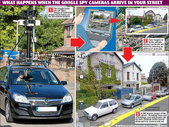
但是,谷歌仍拒绝透露英国版本将在何时搬到网上。最近几个星期,在英国一些城市的街头,带有谷歌标志并且装备有超大的360度照相机的汽车被发现正在绕着街道拍摄。
在美国,"街景地图网站"就已经受到了投诉,理由是侵犯隐私。有张已经被删除的图片显示:一名美国女子从街道上的汽车下来时,不小心暴露了内衣。这个景象被路过的谷歌特型车抓拍到,未经许可就放到了网站上。批评者认为,该网站会被窃贼用作计划逃生路线,甚至会帮助恐怖分子找寻军事基地。
美国互联网专家正在等待法院对"街景地图网站"的高调诉讼做出宣判,一位互联网专家称"街景地图"的潜在危险是:使用它的人可能从人们的工作地点、访问之地认出此人。大多数情况下,这并不会对个人隐私造成影响,但是不排除上保健诊所、医院这样的个人事件被曝光。
国际隐私权保障组织 (Privacy International)警告说,该网站所进行的可能是一个大规模的侵犯隐私权行为。他们准备正式起诉谷歌,除非该公司保证将车牌号码或是人脸全部作模糊处理。一位该组织的发言人说:"在谷歌街景地图完全遵守了当地法律法规之前,我们不会在英国推出它。"
来源:英国每日电讯报,翻译:环球时报
相关文章:
Things you can do from here:
- Subscribe to 月光博客 using Google Reader
- Get started using Google Reader to easily keep up with all your favorite sites
Sunday, July 13, 2008
Google Maps Image Update July 08
Sent to you by 参考消息 via Google Reader:
Another month, another image update! Frank at gearthblog.com seems to have been first to spot that there's new imagery appearing in Google Earth at the moment. Currently unavailable in Google Maps1, the new imagery has so far been found to include:
Best of all (coinciding nicely with our launch of Google Sightseeing Español), it seems Spain has had a major update, which includes:
Catalonia, Murcia, Zaragoza, Toledo, Granada, Cuenca, Cáceres, Valencia, Lleida, Tarragona, Barcelona.
So, has anyone spotted anywhere else with new imagery?2
Categories: Site News
You're reading an entry from Google Sightseeing, which is copyright © 2008 Alex Turnbull & James Turnbull and must not be reproduced without permission.
Things you can do from here:
- Subscribe to Google Sightseeing using Google Reader
- Get started using Google Reader to easily keep up with all your favorite sites